


$15.00
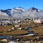
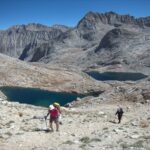
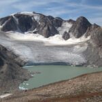
Planning to thru-hike or section-hike the Sierra High Route? This resource will save you time, and help make your experience a safer and more enjoyable one.
Description
When I first hiked the Sierra High Route there was no official or unofficial Mapset or Databook that was publicly available. So I made my own, and post-trip I updated it and made it available for purchase. Aspiring SHR hikers no longer have to assemble their maps from scratch, which is time-consuming.
Table of Contents
Download Instructions
This digital product is available via electronic download. Instructions:
- Complete and pay for your order.
- Check your email. Open the order confirmation email from me.
- To start your download, click the customer-specific download link. This link will expire in 48 hours; if you ever need it renewed, email [email protected].
The download file is 205 MB in size. It is recommended that you have a moderately fast, reliable internet connection before attempting the download.
Product Description
The Mapset & Databook features two versions of the SHR Mapset, plus a Databook, GPX file, and PDF’s of each Map Set version. More detail:
Map Set. There are two versions of the Map Set: one is designed to be printed on 8.5×11 paper; the other, 11×17 paper. Each version contains two sets of maps: one technical set, at a scale of 1:24,000, based on the USGS 7.5-minute quads; and one overview set, at a scale of 1:100,000, based on the USGS 30×60 minute maps. The 8.5×11 version includes 31 technical maps and 8 overview maps. The 11×17 version includes 25 technical maps and 5 overview maps.
PDF’s of the Map Sets. In addition to being available as individual map images (.JPG’s), each version of the Map Set is also available as a print-ready PDF. This is for convenience: it will save you time if you wish to print the entire Map Set or a chunk of it; or it will save you money if you wish to have the entire Map Set (or part of it) printed professionally, since printing companies usually charge a fee for each file they must open.
GPX file. This can be imported into a mapping app like CalTopo or Gaia GPS. It includes the approximate locations of key landmarks (e.g. passes) and a very loose route line. It’s intentionally imprecise — I don’t want to steal from your adventure.
Databook. The databook is a consolidated table of key information from the Map Set. It provides distances between major features like passes, lakes, and trail junctions. It’s an immensely helpful resource: it can be used to gauge progress, plan the day, and coordinate resupply points. The databook is contained in two files: a print-read PDF document; and an Excel file (.xls for PC), if you wish to integrate it into your more extensive planning file.
Mapset Details
The maps were developed using National Geographic’s TOPO! mapping software in conjunction with Roper’s SHR guidebook. Because the SHR is a route, not a definitive trail, and you therefore your actual path needs to be in response to what you see on the ground, I opted to NOT draw a continuous line from Road’s End to Mono Village, which I feared would indicate, “The SHR goes –here–.” Instead, the route is marked with a series of symbols: red diamonds indicate off-trail routes; red flags indicate on-trail segments; yellow diamonds indicate the starting/ending points of the chapters; and red “X” marks mean, “Don’t go here.”
The symbol method also ensured that a minimal amount of topographical data was lost, since there is no thick red line running across the map.
All of the maps are overlaid, i.e. two adjacent maps share at least one common reference point, like a red diamond or a geographic place name (“White Bear Lake”). This makes it easier to align them in the field.
Printing
You have two options for printing these maps: print them at home using your home printer, or have them printed by a professional printing company.
Most home printers are consumer-grade inkjet printers. I have never been pleased with the results: the printers are slow; fine detail is often lost; the ink is prone to bleeding and smudging; the initial cost advantage is often offset by the cost of ink cartridges and high-grade paper; and most home printers do not print double-sided, which means you need to standby in order to feed paper into the printer.
When I need a lot of maps printed, I prefer to have them done professionally. This ensures that the fine detail is preserved and that maps are resistant to bleeding/smudging and flaking. The process is very efficient — I upload the file(s) to the printing company’s website and pick them up a few days later. And the cost is reasonable: I printed two Map Sets for our July 2008 trip at a cost of $80. The maps were printed in color, double-sided, on 11×17 paper; each Map Set contained 33 maps.
Jonathan Ley has put together a lot of helpful tips about printing his Continental Divide Trail maps, which he also makes available on CD. Visit his website for more information.
8.5×11 versus 11×17. The information contained in, and the scale of, each version of the Map Set is the same. But, they are not equal. In my opinion, the 11×17 Map Set is more optimal because it contains more information per sheet — more of the SHR, and more of the surrounding landscape, both of which are helpful in plotting the next few hours of your route from a vantage point. The 8.5×11 Map Set does not contain as much information — your “window” is smaller — and more often you’ll have to hold two maps together in order to figure things out. That said, I recognize that more people have access to 8.5×11 printing than 11×17, which is why I have included this less optimal version.
System Requirements
- Adobe Acrobat Reader
- Spreadsheet software (e.g. Excel, Sheets)
- Document software (e.g. Word, Docs)
Chad Sullivan –
I wanted to thank you for your Sierra High Route mapset. I hiked the whole of the route this september and as i look back on the hike i don’t think i would have attempted the hike or gotten through it without your maps. They were perfect and even the little comments you put on them really helped me. It was my first true solo and off-trail hike and i wanted to thank-you again for in some way being part of it.from one hiker to another
George Matthews, Midlothian VA –
Fantastic! Don’t know if I will hike all of it, but I plan to at least do parts of the SHR this summer. I really like the way you show “the way” versus a red line. I’m sure you expended quite a bit of effort on the SHR map set. Great work! Really professional quality. Plus – your web site info on the SHR is very informative.
Frank Deland, Manchester MA –
In short, Skurka’s SHR maps have saved us both dollars and lots of research hours. When we are preparing to do a section, it’s now much easier to identify the guidebook route descriptions on a topographical map. No longer do I have to search around the guidebook’s grey-toned maps and small print for elusive landmarks — the route on Skurka’s color maps is clearly defined. The 11 x 17 tabloid paper allows you to carry fewer maps.
For example, only three double-sided sheets are needed to cover the route between Tuolumne Meadows and Twin Lakes, and that includes the overview map of the entire section. I took the SHR Map Set disk to Staples to get the maps professionally printed, but you can also print them yourself if you prefer. I have found the Datasheet and the notations on the maps (e.g. unmarked pass names like “Mine Shaft Pass, descriptive guidebook quotes like “distinct red and white melange of rock,” and bits of advice like “No perfect line — just follow path of least resistance”) very helpful too. With only a glance at the Databook, I can easily reference the maps and calculate the mileage between two landmarks, a guidebook chapter, or the entire route.
Jim Sweeney, Berkeley CA –
Andrew Skurka, from whom the English language gets the word “skurking”, meaning moving quickly over great distances in a lightweight fashion (an antonym for “lurking”), has given the lightweight community a tremendous gift in the form of a CD map and data set for Steve Roper’s Sierra High Route. The SHR is a wonderful experience of isolated wildness, exciting route finding, great beauty, and, occasionally, a fatiguing chance to practice ones scree and talus hopping skills.
The CD contains a complete marked route, which opens in TOPO (you’ll need to own TOPO! California for this), two complete Map Sets, in 8.5 x 11 and 11.5 x 17 format, ready for printing, and trail mileage data in two formats. The price, including shipping, is a mere $15 — cheap at four times the price. I know, because I’ve spent hours working out the route using the guidebook and TOPO!, and even then managed to get lost once or twice. There’s no immediate way I can see to improve upon this CD, unless in some future edition Andrew included a raft of photos taken en route.
Dogwood –
No surprise. It’s what I’ve come to expect from Andrew. Excellent, ridiculously inexpensive resource, for section or thru hiking the SHR. Can also be used in combination with other resources for doing off the SHR hikes while basically staying true to a SHR hike. So much level headed insightful commentary on this website as well. Andrew’s route logistical finding skills are top notch which I, also as a long distance hiker, appreciate. Well done. Just wish he had his Hayduke Trail Mapset available when I did that trail without it. Another well done mapset at a very affordable price making that route more within reach of a wider hiker audience as well. Both mapsets excellent for map and compass users like myself.Two thumbs up! Is there a six star rating available for this mapset?
Jennifer Mansbach (verified owner) –
Thank you for making this invaluable mapset available. For our first off-trail cross country hike, my husband and I took our two boys, ages 10 and 12, out for a section of the SHR (Dusy Basin to Puppet Lake) over 8 days and your maps and waypoints made it all possible. We had an epic experience (though I do not recommend Snow Tongue Pass for one’s first off-trail pass!!) and our boys were thrilled with the off-trail experience. We will go back out for more and your maps will be our guide. Thank you again!
Kat Hampton (verified owner) –
These maps and the data book were an essential resource/tool for my solo SHR thru hike last August. They complement the guidebook perfectly, and are in keeping with the off-trail spirit of the route. Skurka’s hints and waypoints were minimal enough to allow me plenty of navigation “learning opportunities,” and blunt enough where necessary to help me avoid dangerous terrain. The guidebook is essential (take the guidebook!), but take these maps too, and your experience in the High Sierra will be an excellent one.
Stuart Smith (verified owner) –
The maps were very easy to download and to have professionally printed. I created a FedEx account and uploaded the 11×17 PDF file to the FedEx account and then went and picked the maps up at the FedEx store that afternoon. Well worth the $40 that FedEx charged for quality smudge-free maps on sturdy paper rather than trying to print myself at home.