


$25.00
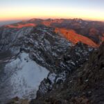
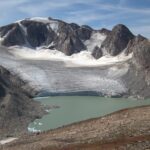
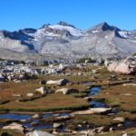
An instant classic, and one of the finest routes in the High Sierra, the Kings Canyon High Basin Route circumnavigates the upper watershed of California’s Kings River. The 124-mile route is two-thirds off-trail and features 16 passes above 11,000 feet.
For aspiring KCHBR thru- and section-hikers, the Guide is a must-have resource. It includes a planning guide, route descriptions, data sheets, and complete topographic map set.
Description
In the Kings Canyon High Basin Route minisite, I have posted extensive information to help you determine the appropriateness of this route for you.
Whether you’re on the fence or have already blocked out dates on your calendar, the next step is to download the Kings Canyon High Basin Route Guide, which includes must-have resources for thru- and section-hikers. The Guide includes:
Guidebook
The Guidebook has three parts. Part 1 contains planning information. Part 2 and Part 3 are field guides: the Primary Route and its Alternate Routes are described in Part 2, and the Section Hikes and their Alternate Routes are described in Part 3.
Each part is a separate PDF file, designed for printing on Letter 8.5 x 11 inch paper. Part 1 need not be printed since it has minimal or no relevance in the field, but you may prefer a physical copy to read and annotate before your trip. Thru-hikers should print Part 2. Section-hikers should print from Part 2 and Part 3 the pages that are relevant to their itinerary.
Part 1: Before you go
It seems appropriate to cite the British Army’s 7 P’s: “Proper planning and preparation prevents piss poor performance.” The Kings Canyon High Basin Route is an ambitious and committing route, and some consideration beforehand is prudent. Part 1 will help you plan a seamless trip and to arrive at the trailhead fully prepared for the experience ahead. Contents:
- Permitting
- Transportation
- Nearby Services & Resupply
- Pertinent rules & personal conduct
Remember that there is also extensive information in the minisite.
Part 2: Primary Route
The route description for the Primary Route and its Alternate is written end-to-end, going counter-clockwise from Lodgepole and finishing at Road’s End. Thru-hikers will need to have Part 2 in its entirety, while section-hikers will only need to bring relevant pages.
Part 3: Section Hikes
For most backpackers a thru-hike will demand too much: time, effort, and/or backcountry skills. So I have created nine worthy Section Hikes ranging from 30-80 miles that cover the entire route. Part 3 of the Guidebook contains route descriptions for them and their Alternate. Where the Section Hike follows the Primary Route, toggle to the appropriate pages of Part 2. The Section Hike descriptions are written in the direction of travel that I have deemed to be optimal, which may or may not be consistent with the Primary Route description.
Data Sheets
Databooks
These quick-reference spreadsheets list the distances and vertical change between key landmarks. They are extremely useful in planning your trip, scheduling your day, and gauging your pace. Databooks for the Primary Route, Section Hikes, and Alternates are included.
Turn-by-Turn
In general, Section Hikes begin at a trailhead off the Primary Route, hike up to and join the Primary Route, and then return to the original trailhead. But it is more complex than that: some routes used to access the Primary Route are shared by other Section Hikes, and the optimal direction of travel for the section-hike may not be counter-clockwise, as it is for the Primary Route. The Turn-by-Turn sheet tries to make sense of this, while still calculating accurate distance and elevation information.
Topographic map sets
The Guide includes a complete and excellent set of topographic maps, with separate print-ready PDF’s for the Primary Route and its Alternates, and each of the Section Hikes plus their Alternates. The maps were developed using CalTopo, using the USGS 7.5-minute series as the base map. The maps are annotated with key points and critical route information, with such detail that the route descriptions in the guidebook are not always critical.
When printed on 11 x 17 paper, the map scale will be its native 1:24,000. Printing on smaller paper will compress the topographic detail, perhaps to the point of being illegible. Contour intervals are 40 feet or 20 meters (65 feet), depending on the original base map, some of which are in Metric and others of which are in Imperial.
Download details
With a decent internet connection, the entire Guide can be easily downloaded. The files have been compressed into a single zipped file and must be extracted using standard Windows or Apple software before accessing.
If you need a copy on DVD, please contact me with your mailing address, and attach a receipt of purchase.
Must-have resources not included
The KCHBR Guide is designed to be a comprehensive one-stop resource for a thru- or section-hike. However, I recommend a few additional resources:
- Kings Canyon High Basin Route minisite
- Park overview map, specifically the Sequoia-Kings Canyon National Park Map (#205) by National Geographic Trails Illustrated
- Other guidebooks and online resources that will complement the information in the Guide
- Proper gear
- Backcountry experience
- Fitness
- Sense of adventure
Comments and questions
The Guide contains a tremendous amount of information and I’m very proud of the end product, but I can almost assure you that it is still not perfect. If you find errors or have suggestions, please contact me, leave a comment in the minisite, or write a product review for the Guide. Thanks, and have fun out there!

Krishna Dayanidhi –
I just came off this hike with 2 others. We completed ( nearly) Loop1, one of the section hikes from this guide, in 5 nights, 6 days.
Mile for mile this is one of the most amazing hikes I’ve done. The on trail sections are, of course awesome but the off trail sections are where the route really shines…remote and gorgeous, they’re challenging but not insanely difficult. We didn’t see any humans from Sunday evening until Wednesday afternoon when we got back to trail.
For $25, this is not a bargain, it is a giveaway. Considering the costs that go into the actual implementation of a hiking trip, this will be the best $25 you have ever spent on a hiking trip.
I can’t wait to go back and try one of the other section hikes
Blake Boles (verified owner) –
My friends and I did a 5-day, 49-mile section of the Kings Canyon High Basin Route, and we were very impressed with the quality of Andrew’s materials. The details are on-point, the maps are comprehensive, and the mileages are accurate: everything you could want in a map and data set. Highly recommended.
Our trip report: http://www.blakeboles.com/2016/08/trip-report-kings-canyon-high-basin-route/
John Paul Castiaux (verified owner) –
Hi there, what is the latest version, or have there been no updates since 2015? Thanks!
Andrew Skurka –
If your download includes a file named something like, “Critical interim updates,” then you have the most recent copy. We’re working this year on updating this guide and most or all of the others.