


$25.00
The digital Yosemite High Route Guide includes must-have resources for thru- and section-hikers, including:
- Planning information,
- Annotated topographic maps,
- Datasheets,
- Route descriptions, and a
- Rudimentary GPX file.
Description
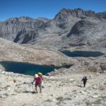
The Yosemite High Route explores remote canyons, expansive alpine areas, and pristine lakes in the upper headwaters of the Tuolumne and Merced Rivers. It’s encompassed entirely within America’s third-oldest national park, and can be undertaken as a thru-hike or in shorter sections.
The digital Yosemite High Route Guide includes must-have resources for thru- and section-hiking the Yosemite High Route, including:
- Planning information,
- Annotated topographic maps,
- Datasheets,
- Route descriptions, and a
- Rudimentary GPX file.
Status
This guidebook is a work in progress, and always will be. It’s functionally complete, and has been used by dozens of hikers to complete thru- and section-hikes of the route.
As of January 2022, the only missing content is in Part B of the guidebook (“As you go”), specifically, descriptions of eight on-trail approach routes to the termini. With basic map-reading skills, these sections should not pose any challenges.
Format
The Yosemite High Route Guide is a digital product. With a decent internet connection, the entire 800-MB package can be easily downloaded. The files have been compressed into a single zipped file and must be extracted using standard Windows or Apple software before accessing.
If you need a copy on DVD, please contact me with your mailing address and include a receipt or your order number.
If your access expires before you have had a chance to download the files, of if you lose the files at some point, contact me so that I can renew your access.
Mapset
The Guide includes a complete mapset for:
- The entire Core Route,
- Twelve Approach Routes to the Core Route,
- Five short alternates to the Core Route and Approach Routes,
- Eight recommended Section-Hikes.
The maps were developed using CalTopo, using as a base map the USGS 7.5-minute or FSTopo 2016 topographic series. They are geo-referenced PDF’s. When printed on 11 x 17 paper, the map scale will be its native 1:24,000. Printing on smaller paper will compress the topographic detail, perhaps to the point of being illegible. Contour intervals are 40 feet.
A recommended line of travel has NOT been drawn onto the maps. Hey, I didn’t want to steal your fun by telling you exactly where to go. To help guide you, instead I have marked notable landmarks, including intersections, creek crossings, and passes. Your job is to essentially “connect the dots,” following the route description and the point order on the Datasheet.
Printing tips for topographic maps

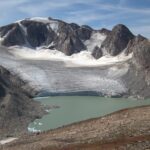
Screenshot of the topographic map for the Core Route
Guidebook
The Guidebook has three parts:
Part 1 (“Before you go”) has information to help you plan your trip, e.g. transportation, permitting, direction of travel, resupply, recommended equipment. This information is in addition to the preparatory materials at the mini-site.
Part 2 and Part 3 (“As you go”) are complementary to the Mapset. They offer general information and context, and in-depth route information for sections that really need. The Core Route and Approach Routes are described in Part 2. The Section Hikes are described in Part 3.
Download pages 1, 2, and 5 of Part 2

Screenshot from Part 1: Before You Go.
Datasheets
These quick-reference spreadsheets list the incremental and cumulative distances and vertical change between key landmarks. They are extremely useful in planning your trip, scheduling your day, and gauging your pace. Datasheets for the Core Route, Approach Routes, and Section Hikes are included.
Download page 1 of the Datasheet for the Core Route

Screenshot of the Datasheet for the Core Route
GPX file
I have included a GPX file with very limited information. You’ll find trailhead waypoints and a crude track that will help you identify the topographic map tiles you need to download onto your handheld GPS or smartphone. It does not include a track for the recommended route — that’s for you to figure out.
Early-season hazards
Snow and water hazards will be encountered on the Yosemite High Route through June (after a normal winter, plus/minus after non-normal winters).
After early-season research in July 2019, I will share a consolidated list of these hazards, and perhaps narrative instructions for the trickiest spots. This information will be consolidated into the Second Edition of the Guide.
Resources not included
In addition to the detailed set of topographic maps included with the Guide, I would also recommend:
- National Geographic Trails Illustrated #206, a large-scale map of the entire park; and,
- Digital maps of your route, stored on a handheld GPS or your smartphone. I specifically recommend GaiaGPS or CalTopo.


Gabriel Newbell –
This seems like the other comment I found earlier.
Andrew Skurka –
I’m uncertain what you mean.
Ken Burtner –
Hey Andrew,
Is the YHR Guide completed? (1/9/2020). I’ve enjoyed your SHR package and am ready for more!
Andrew Skurka –
It’s pretty darn close. Route description is the only thing incomplete, and it’s about 80 percent done.
chain –
Thanks again for the article. Really thank you! Keep writing!.
Anja Pakendorf (verified owner) –
I could not download the set…timed out, then told me I exceeded downloads…sent an email with details.
Andrew Skurka –
We had a personnel change recently and this may have fallen through the cracks, sorry about that. I thought we’d avoided that. I’ll follow up with you directly and reset your download link.
Andrew Skurka –
I just reset your download links. Use the links in the original email receipt. They’re all pretty big files, so I’d do one at a time so they download without interruption.
Jim Ruppert (verified owner) –
Also having download issues …
Andrew Skurka –
Use the contact form, https://andrewskurka.com/contact/
Jon Gray (verified owner) –
Hello Andrew! A few years ago completed the wonderful south loop, and this year looking at the North Loop (after spending 3 years completing the amazing WRHR). Wondering if you have any comments on the Grand Canyon of the Tuolumne vs PCT approaches to the Northern terminus. Pros/cons of each? Thanks!!!!
Andrew Skurka –
The guidebook has some discussion. They are pretty different routes, with the GC dropping quite low and the PCT hopping up and down through the mid-elevations. If it’s earlier in the year and/or not exceptionally warm during your trip, I’d generally favor the grand canyon, because it’s more different than the rest of the route. Just by looping back on the YHR you will get a flavor of the PCT terrain.