Planning

Through the beginning of March, California was having an extraordinary winter. Snowpack in the High Sierra was keeping pace with the wettest winter on record, 1982-83. If the trend had continued, conditions would have been very challenging for aspiring Pacific Crest and John Muir Trail hikers, due to extensive lingering snowpack and high run-off, probably…

A reader question from Gabino: I’m sure that every backpacker planning to undertake the PCT, JMT, Sierra High Route, Kings Canyon High Basin Route, or any other high-elevation route in California’s High Sierra is wondering the same thing right now. Here are some thoughts: California’s snowpack: The Facts There are many ways to record and analyze…

Along the Pacific Crest and Continental Divide Trails, closures and fire bans are considered normal, especially after dry winters or late in the summer. Ditto for other long trails through arid or semi-arid environments like the Arizona Trail or Colorado Trail. But I considered such trail closures impossible on the Appalachian Trail, which is nicknamed “The Green Tunnel”…

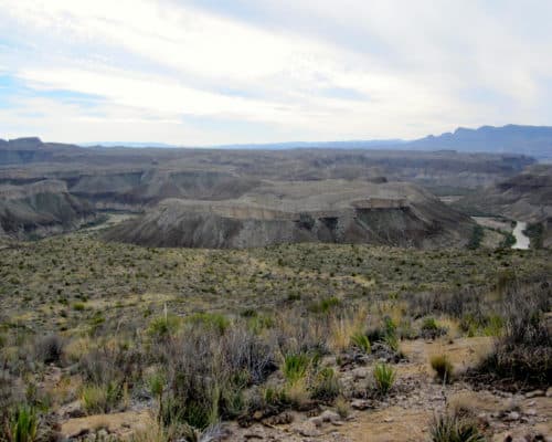
The Sierra Nevada mountains are world-class, encompassing two National Parks (Yosemite and Sequoia-Kings), the John Muir Trail, and a half-dozen Wilderness Areas like Desolation, Golden Trout, and Emigrant. The heart of the range extends from the Kern River in the south, to Lake Tahoe in the north. Backcountry use is accordingly significant, by residents of…

Within the backpacking community I have sensed increasing interest in “high routes,” such as the the Sierra High Route, Wind River Range High Route, and Kings Canyon High Basin Route. I think this concept will continue to expand, with most of the emphasis on “route” rather than “high,” since there are thematically similar opportunities in…

Today we’re fortunate to have excellent online mapping platforms like CalTopo, Hillmap, GaiaGPS, and AllTrails. But until these platforms are available deep in the backcountry on devices that don’t break or need recharging, as part of my trip planning routine I export and then print my digital maps into a field-friendly paper set. Here is how:…

I have planned hundreds of backpacking trips. Many have been personal outings, ranging from long weekends in nearby destinations to multi-month thru-hikes in faraway places. The rest have been guided, when I’ve been accountable to paying clients. To maximize my working efficiency and to prevent oversights when getting backpacking trips out the door, I use a trip planning checklist — a spreadsheet,…
Editor’s Note. Russell has been on two of my guided backpacking trips, and in April will join a third. He considers himself an “advanced beginner” backpacker, getting out a few times per year on trips of 2-4 days each. In mid-December I did a short trek with my wife and two sons at our favorite…
The first year I offered guided backpacking trips and courses in 2011, preparations for them were disastrously inefficient. My systems were nicely refined for solo thru-hikes, but I learned that groups of up to 10 clients for 3, 5, or 7 days at a time entail much more: more logistics, more food, more group equipment,…

Be Prepared? Absolutely. But against what? Why and how to assess environmental and route conditions.
On every backpacking trip, I have three primary goals. In order of importance, they are to: Survive, Maintain a realistic level of comfort, and Have “fun,” the definition of which is subject to personal interpretation. When I embark on a trip, I always try to abide by the Boy Scout motto — “Be prepared” —…