Even within Alaska, the Brooks Range — which extends 700 miles across the state, from the Canadian border to the Chuckchi Sea — is considered to be the ultimate wilderness. It’s crossed by just one gravel road, has just one tiny Native village within its mountainous core, and has no man-made hiking trails.
Gates of the Arctic National Park encompasses the central Brooks Range, arguably its most aesthetic and diverse section. It was established in 1980, as part of the monumental Alaska National Interest Lands Conservation Act (ANILCA). At 7.5 million acres, it’s the second largest National Park and is 3.5 times larger than Yellowstone.

Why go here?
The primary appeal of Gates of the Arctic is its wilderness character, which is virtually unchanged since people of European descent first began to explore the area in the 1880’s.
Inside the park boundaries, there are no roads or dams, and the only “trails” are those made by wildlife, including grizzly bears, wolves, Dall sheep, moose, and most importantly the Western Arctic Caribou Herd, which stands at about 225,000 animals and which migrates through the park twice each year.
For a backcountry enthusiast, Gates offers spectacular backpacking and rafting opportunities.

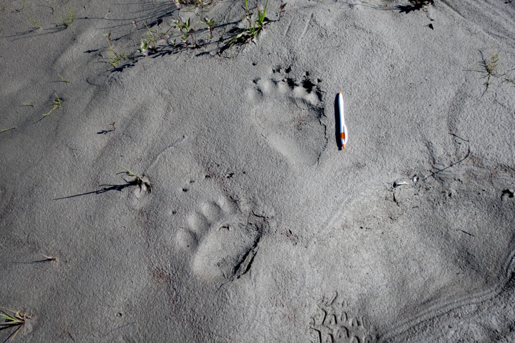
Grizzly tracks on a gravel bar Probably not a golden retriever

Where is it?
Gates of the Arctic encompasses the central Brooks Range in northern Alaska, and is entirely north of the Arctic Circle.
Fairbanks is the closest city with full services and a large airport. It’s a seven-hour drive north from Fairbanks to the town of Coldfoot, located just outside the park’s southeastern boundary.
What is the Brooks Range?
The Brooks Range extends 700 miles across northern Alaska and divides the state’s Arctic and Interior regions. It’s the northernmost extension of the Rocky Mountains, and is composed mostly of sedimentary layers like limestone and shale.
Only one gravel road, the Dalton Highway (aka Haul Road), crosses the Brooks Range. And only one 350-person Native village, Anaktuvuk Pass, is located within it; about a dozen similarly sized communities are on its outskirts, mostly to the south.
The National Park Service and US Fish & Wildlife manage most of the range, as Gates of the Arctic National Park in the central Brooks, and as the Arctic National Wildlife Refuge in the eastern third.
How do I get there?
It’s difficult and expensive to reach Gates of the Arctic. As a result, you will not encounter crowds in gateway towns, and you are unlikely to see other parties in the backcountry.
1. By vehicle
The park’s eastern boundary can be accessed from the Dalton Highway, a well maintained gravel road that primarily services the oilfields in Prudhoe Bay but that is also open to private vehicles. From Fairbanks, it’s an eight-hour drive to the first practical access point near the Chandalar Shelf.
2. By passenger plane
Wright Air Service and Everts Air Cargo offer regularly scheduled flights to Anaktuvuk Pass ($190 one-way). From town, hike east or west on mostly good tundra, or float south on the John River (Class III) after a 5- to 10-mile portage.
3. By bush plane
To access most of the park, it’s necessary to use a bush plane, departing from:
- Fairbanks
- Coldfoot, or,
- Bettles.
Fairbanks has an international airport and is serviced by major carriers like United, Delta, American, and Alaska Airlines.
Coldfoot is on the Dalton Highway, seven hours north of Fairbanks. Wright Air offers daily Fairbanks-Coldfoot flights ($230 one-way).
Bettles is not on the road system. It can only be reached via Wright Air ($170 one-way).
For a list of authorized air taxi services, consult this list from NPS. In Coldfoot, try Coyote Air; in Bettles, Brooks Range Aviation.

When should I go?
The park is open year-round, but some seasons are more conducive to backcountry travel than others.
- Winter (November through March): Brutally cold, stormy, very limited daylight, and few open services.
- Spring (April and May): Cool temperatures, increasingly long days, lingering rotten snowpack.
- Late-spring (June): Mild temperatures, 24 hours of daylight, manageable bug pressure, some lingering snow at the highest elevations, generally stable weather.
- Early-summer (July through mid-August): Heavy bug pressure, the wettest months of the year.
- Late-summer (mid-August through September): Comfortable days and crisp nights, no bugs, and fall foliage; but still stormy, and competition for bush planes with hunters.
- Fall (October): Rapidly decreasing daylight, cold temperatures, not yet winter.

What backpacking routes do I recommend?
I’m wary of discussing specific routes in the park. There are many stellar options, and currently backcountry traffic is nicely dispersed.
The best travel in Gates will be found:
- Above 2,000 feet in the southern watersheds, e.g. North Fork, John, Alatna, Kobuk;
- On dry, well drained slopes;
- Adjacent to large and small rivers, on current and mature gravel bars; and,
- Along wildlife trails, particularly those made by caribou.
When planning a route, your goal should be to maximize the distance of good travel and to minimize the bad.

What should I pack?
Full treatment of this question would warrant a standalone post. In lieu of that, start with my Brooks Range gear list for June, which can be tweaked for other seasons.
Do I need a permit? And other regulations
A wilderness permit is not required in Gates of the Arctic, but NPS asks that at a Visitors Center or Ranger Station you:
- Leave an itinerary, for the sake of your safety and for visitor statistics;
- Complete a backcountry orientation.
Food must be stored overnight in an IGBC-approved canister or sack, per NPS regulations. I recommend using an Ursack Major or Major XL, which are much lighter and packable than hard-sided canisters. Refer to my buyers guide for more information.
Should I just hire a guide?
Even for competent backcountry travelers, Gates of the Arctic can be overwhelming. The logistics are complicated; the number of route options is infinite; the terrain is unlike anything in the lower 48; and multiple hazards must be managed (e.g. bears, river crossings, remoteness).
With a well developed skill set and extensive planning, private parties can successfully undertake trips in Gates of the Arctic National Park. But for those short on experience or time, a guided trip may have a better outcome.

Where can I get more information?
The National Park Service website has basic information and is marginally helpful.
For a large-scale planning map, I recommend the National Geographic Trails Illustrated #257.
Elsewhere online you will find a handful of trip reports, but none provide plug-and-play itineraries (probably intentionally). Ironically, one of the best sources for route information is Robert Marshall, who documented his exploration of this area in Alaska Wilderness. The text was written in the 1930’s, but it’s still relevant today.
Disclosure. I strive to offer field-tested and trustworthy information, insights, and advice. I have no financial affiliations with or interests in any brands or products, and I do not publish sponsored content
This website is supported by affiliate marketing, whereby for referral traffic I receive a small commission from select vendors like Amazon or REI, at no cost to the reader. As an Amazon Associate I earn from qualifying purchases.
I know you had a few guided trips last month. It would be great to hear how they went wrt to itinerary, fitness required, any interesting encounters/events.
They went great. Three out of the four were perfect 5/5 (at least I thought so; I’ll have that confirmed or disputed when I send post-trip surveys this week), and one of the groups was a bit over-stretched but I believe they had a great time anyway. Great conditions, great routes, great groups. I put a lot of pressure on myself to at least meet expectations (in this case, a $4k per client expectation), and I feel really good about this block.
Due to time constraints (my CA trips start on Friday), I probably won’t post anything (if anything at all) about these trips until August.
It may sound selfish, but please refrain from advertising Gates of the Arctic, lest it becomes another Yosemite. If they have money, the riff raff will eventually be there.
Very useful info. Is it difficult to find satisfying routes that don’t involve packrafting or crossing major rivers? Also, stable weather and no bugs in early June sounds really appealing. Would early-mid June be a good time for a Brooks trip in a typical year or is it still shoulder season?
Going to Alaska soon (most like Denali NP). Usually I try to use a map and compass as much as possible (printed from Caltopo) and also have Gaia syncd on my phone for backup use.
Lately I’ve been eyeing the old school Garmin Foretrex range – no maps in the device but they released updated models this year that do GPS and Glonass with some insane battery life off one lithium primary. Basically great for cold weather and ultra reliable.
Do you think a device like this is still relevant in today’s world? A phone can easily be broken, and I find the screen showing Topo maps on most handheld GPS so small it’s almost useless. I’m leaning towards a device like the Foretrex that still will give me a GPS lock and then just printing UTM on my maps as I usually do, or even lat long. This is mainly for backcountry off trail by the way – say like 7 to 10 day trips.
I think handheld GPS units are antiquated. GaiaGPS ate Garmin’s lunch.
Buy a case for your phone to make it more tactile and to protect it some.
One of the great things about Gaia is that you can display the exact same maps on the phone as you have printed out. In your case, it will be the 15-minute USGS maps. So when you ask Gaia, Where am I? It will show you exactly where you are on your printed map.
That’s a great point – I was looking at huge battery replacements (I have one of the last androids that had a removable battery) but I had not considered an extra durable case.
What I really actually would love is essentially a super simple and light GPS keychain – essentially a small receiver that has a super basic LCD and that’s it. With something like in manual location request only mode I think it could theoretically be used for maybe months at a time. I did find some cheap AliExpress trackers that are somewhat similar, but in the end they’re low quality and unreliable. Would be nice to have as an emergency sort of backup or for fast and light trips when I don’t even bring a phone usually. But it’s definitely a niche product.
Agreed! I’ve been using GaiaGPS for years.
Great summery! I think Everts also flies into Anaktuvuk Pass. http://evertsair.com/pages/pax/schedule.php
Hey Andrew
I have a 32 degree Western Mountaineering summer lite mummy bag – would this suffice for mid to end of August?
Instead of simply telling you yes or no, let me give you a link so that you can inform these decisions on your own, https://andrewskurka.com/backcountry-weather-conditions-forecasting-methods-sources/