On a fateful Sunday I found a reference to Jamal Green’s website, Across Utah!, and to his videos about his trek. Caution: Time sink! After studying this project for a year, I decided it would be my first post-retirement hike. So that I was ready to do the hike in the spring, conveniently it locked in an end-of-year retirement for me — this trip was the perfect excuse to make it happen!
Walk Across Southern Utah takes you from the western border of Colorado to the eastern border of Nevada, starting with the La Sal Mountains finishing with the Pine Mountains. Its crosses four National Parks (Canyonlands, Capitol Reef, Bryce, and Zion), Grand Staircase-Escalante National Monument, several mountain ranges, and the Colorado River. The total distance is 700 to 750 miles.
It has been hiked in the reverse direction, notably by Paul “No Breadcrumbs” Magnanti. Apart from Jamal Green’s videos, I’m only aware of one other report, from Amy Lauterbach & James Yurichenko, who hiked in a westerly direction.

Quickstart guide: Walk Across Southern Utah
The aforementioned trip reports are more philosophical than practical. I appreciated the vivid impressions of what they experienced and their general musings, but they lacked details that I would have liked to have had before I left. So here I will provide some succinct and actionable information, as a succinct supplement to more details on my own blog, Thomas Hikes.
WASU vs Hayduke Trail
The more established and popular route across this region is the Hayduke Trail, and a first obvious question is, Why do the WASU route instead of the Hayduke?
After having read several Hayduke Trail trip reports by people who have hiked many more miles than me, I was frankly intimidated by several aspects of the route, particularly the sections in the Grand Canyon. Being an old guy I typically hike solo. One of the consequences of hiking solo — if that is your preference or your only choice — is that you have no second opinion, nobody who will take the lead for a stretch so that you can recover mentally, nobody who will push back when you are about to screw up. At the time I did not feel ready to complete solo the Hayduke. Period.
Getting to the start
I took a page from Amy & Jim’s playbook and started the hike in Gateway, Colorado on Highway 141. The hike starts outside of “town” by walking John Brown Canyon. This has the advantage that you can tell whoever picks you up where exactly you want to go on Highway 141 and you can hold up a printed sign with your destination, as I always do. I’ve been told that this had a positive on the driver’s decision to stop.
I took the train from Oakland to Grand Junction (24 hours!). I next did my caching and after a night in a motel in Grand Junction I took a cab to the Junction of US 50 and CO 141S (~$25) and hitchhiked to Gateway. Worked like a charm.
Getting back from the finish
After reaching the Nevada border, hitchhike to Cedar City, Utah, from where you can take a one-hour flight to Salt Lake City or to Las Vegas ( ~ $100 one way).
The highlights
You will probably meet (few) people along the way. But they will really restore your faith in humanity. Incredibly kind and generous. I had several people go way out of their way to offer help when I needed it or when they thought I needed it.
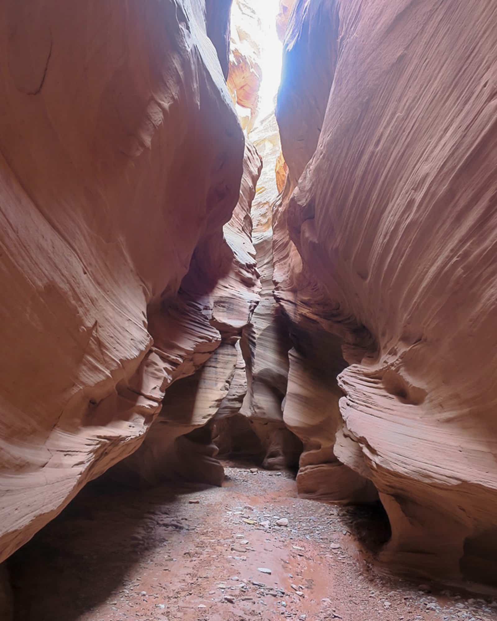
In terms of geology and vistas, the most remarkable stretches include the fins above Moab (Moab to Behind the Rocks), the Needles, the Doll House, Pete’s Mesa and Ernie’s country (all in Canyonlands), Happy Canyon slot canyon, Capitol Reef and Upper Muley Twist canyon, Boulder Creek/Escalante River, Hackberry Canyon and the Stone Donkey/Hogeye canyon system, North Fork Virgin River, Zion.
While the wildflowers were not as abundant as the Rockies in July, in 2019 they nonetheless far exceeded my expectations. I just loved hiking through this gray/beige/brown/red country and all of a sudden encountering an Indian paint brush or a cactus with their bright red flowers.

Section-hiking
If you have friends or family visiting the area, you could plan section hikes and be picked up at a convenient location. If you had to rely on hitchhiking to get out of the backcountry, you would likely have to be very flexible with your travel arrangements.
Requisite backcountry skill & experience
You should have your gear dialed in, you should be comfortable with orienteering (compass/map work/GPS), you should have your water management down pat, you should be comfortable in the backcountry and know how to keep your cool when things go awry, and you should be comfortable to be without human contact for extended periods of time if you do this solo.
This should not be your first long-distance hike and not your first hike with significant off-trail travel, especially when you are solo. If you are tired of “hiking by the numbers” on the Cadillac trails, maybe this is for you.
For me, it was the first hike with significant off-trail sections since serving in the Army forty years ago, and I had taken significant recourse since then. In preparation for this adventure, I took a 5-day Adventure trip with Andrew in Rocky Mountain National Park, and at its conclusion was confident that I was “ready.”

Managing risk
You will be walking through some fairly isolated country, bailing out is going to be neither easy nor fast. Traffic on the few roads you will be crossing is very light, often less than 10 cars per hour. You then apply your personal experience of how many cars will pass you by until you get a ride and you can estimate how long you’re going to be standing there.
Know your limits and have a clear understanding of the risks you are willing to take and which ones do not compute in your risk/reward calculation, regardless of how many others have gone up or down that specific spot that you are contemplating. I got really frightened in one spot in the entire route, and I talked myself through it, but that really went right up to the limit of what I am/was willing to risk.
I think that an emergency beacon of some kind and a support crew that monitors your progress on a daily basis are absolutely necessary. Your support should have a detailed hiking plan and agreed upon procedures for what to do when your location information does not come in in the evening.
Resupply
I am somewhat particular in what I wish to eat on a trip like this, especially in terms of salt and sugar content. It is unlikely that your typical country store will be able to cater to preferences like mine. Moab is fine; Escalante, Canonville, and Tropic are less satisfactory.
I therefore drove along the route beforehand to cache some food, fuel and water in spots that were respectably distant from the next resupply point, notably Needles Outpost, Poison Spring Rd/Highway 95, Capitol Reef, and Carmel Junction.
This reduced the amount of food I had to carry and I had more capacity for carrying water while maintaining a reasonable total pack weight. I would do the same if I were to do this hike again. It took a total of two-and-a-half days to place the caches which to me seemed a small price to pay in terms of time and money.
West of Bryce, there is a higher density of small towns with post offices. So I mailed parcels to myself via General Delivery (or had my support crew do this for me) at these locations.
This also requires meticulous planning because of funky opening hours of some of the PO’s and the maximum hold times of USPS. Next time I will send a message from the trail to the crew on when to send the next set of parcels rather than estimating my hiking time ahead of time.

Seasonal considerations
I hiked from mid-April to end of May in a westerly direction, as did Amy and James. Paul hiked in an easterly direction from mid-October to mid-November. Paul and Amy & James completed the hikes in about 35 days.
My total time was longer, but my net time for this route was about the same time. I encountered some problems with the availability of permits to cross Canyonlands NP and Zion NP that had me spin my heels for a few days, which added to the total time.
It may be possible to start a little bit earlier in years with average or sub-average snowfall. But unless you are keen/willing/able to carry snow travel gear across the LaSal and the Henry Mountains, we’re talking only a few weeks at most.
In spring 2019 the La Sal’s had 300 percent of their normal snowfall. I was lucky to make it across the lowest — and my least preferred — of three potential routes I had scoped out across that range. The Henry Moutnains had not thawed out at the peaks, but the road I was using was snow-free except for the new snow that was falling while I was crossing.
After speaking to locals along the route, I think you could also start somewhat later and finish, say, mid-June, meaning a start in late April/early May.

Crossing the Colorado
I crossed the Colorado on a packraft that I had stashed at Needles Outpost while caching supplies. On my blog I’ll discuss this method more in-depth.
The alternative is to catch a ride across the river from Tex’ Riverways’ jet boat shuttle. This boat comes down to Spanish Bottom to pick up groups who have floated the Green and Colorado rivers on canoes or inflatables and returns them to Moab.
I have no idea whether the shuttle across the river is a courtesy or whether they charge a fee (I suspect the latter). They know days ahead when they will be going down to Spanish Bottom, so you should be able to plan accordingly in consultation with their Moab office (435) 259-5101). No connectivity down by the river!
On days when no paddlers are to be picked up, there will be no jet boat and hence no ride across the river. You need to be down by the river by 9:30 AM. That’s when the boat is about to arrive. By 10:45 AM they are heading upstream and there won’t be another boat for the day.
Do not even dream of crossing the river by swimming or floating on your inflatable mattress! The water is very cold, there is a lot of debris floating on the river that you can get entangled in, there are rakes (tree branches reaching down into the water on the Western shore) that push you under, and getting out of the water is very difficult (the banks are made of mud/sand that crumbles into the water if you were to attempt to pull yourself up).

Maps
I did all my map work in GaiaGPS using USGS, USFS and Nat Geo (for NPs) base maps. Jamal as well as Amy & James have Google maps on their respective websites showing their route to get you started.
Water
In Spring 2019 water was abundant, by Utah standards, but you had to still work for it, specifically finding promising spots for collection. Since you are also likely going to consume a lot of water (on days when the wind was blowing and no cloud was to be seen in the sky I used a minimum of 4L during the day alone), this is something that you need to consider for your purification strategy.
You will likely have to expand considerably the range of water sources you think are acceptable. There are four major sources of crude water: potholes under dryfalls and on rocky flats (best), cow water (“Château Bœuf”), road run-off (“Château 2CV”) and creek/river water (second best).

Permits
Backcountry permits are required for several spots.
Canyonlands NP
You need permits for the Needles district and the Orange Cliffs section at a minimum. There are about 10 backcountry permits available per night for hikers in each of the two or three zones you are crossing. The passage through the Maze is optional, but if you are passing by there, it would be foolish to not take that side trip.
So you want to get this set up well ahead of time (up to 4 months to the day) and make sure that you are on time to pick up your permits. I was somewhat impatient with the low quota of permits (“What are they thinking?”). After having hiked through and having seen the water situation in the backcountry up close and personal I now understand why the quota is what it is.
Capitol Reef
A permit is required for staying overnight inside the park. In this park the permits are not scarce as in Canyonlands NP. However, it is easy to camp on the eastern border just outside of the park, cross it during the day, even if you take the scenic route, and get out the other side the same day.
Park headquarters is pretty far away from the trails you will be walking, therefore last minute adjustments are not easy. It is difficult to predict accurately when exactly you will be crossing.
I avoided this permit issue and would encourage you to do the same. An alternative is to request a permit with a larger time window around the day you expect to be in the park. I understand that they have stepped up their enforcement activities because, I was told, Hayduke hikers were flouting the rules.
BLM permits
The town of Escalante has an Interagency Office where I got my permit for the hike beyond town. This is uncomplicated in comparison to the National Parks permits, as the camping is “at large.” The “permit” is really mostly for use statistics I suspect and for SAR purposes if you get lost.
For the stretch between Canonville and Zion I obtained a permit at the Canonville BLM office (Note: they have some funky operating hours at Canonville due to lack of staff).
Bryce
I had been to Bryce several times before, so I had no need to hike inside the park.
Zion
This is complicated. One obtains backcountry permits from the main office inside the park.
I shudder to think what it would take to get a contiguous permit for the East and West rim. Normally one would hike the East rim, descend down to the park road and climb up the other side to the West rim. While the East rim has some “at large” camping zones, the west rim does not.
As of summer 2019, part of the East Rim Trail is closed due to a major rock slide (and they mean the “closed” part, because they threaten some serious monetary consequences if you get caught ignoring the closure). I suspect that closure is going to last a good while since the slide was major and there is concern about the stability of the rock face still standing.
I spun my heels for a couple of days on the East rim before I could secure a permit for the West Rim hike with camping for two nights. Zion is the only place that I ran into a ranger who checked my permit.
Camping in the campground inside the park is sold out weeks ahead and there is no set-aside for through hikers nor do they make available sites for which an issued permit is not being used. I had good luck with throwing myself on the mercy of people who had a campsite. There is one private campground right outside the park in Springdale ($$$) and one not too far from the East gate ($$$).
Have questions about my Walk Across Southern Utah? Leave a comment.
Tags:
“The aforementioned trip reports are more philosophical than practical. I appreciated the vivid impressions of what they experienced and their general musings, but they lacked details that I would have liked to have had before I left.”
Much of that info, with more details in some cases, here:
https://pmags.com/wasu-overall-thoughts
Thomas! Are you the German chemist I met as I also walked across Southern Utah????? (I went West to East on a different route Red Cliffs to Mesa Verde). I believe we met as you descended Tarantula Mesa? You informed me about potential problems with aquamira and alkaline water – good to know, as well as beta on the snow situation in the Henry’s???? also good to know! It was very nice to meet you. Thanks for sharing the write up and take care???????????? (Say hi @robert_cusimano on Instagram if so inclined.)
Yep, that’s the Thomas you met.
Congratulations Thomas! That looks like an epic trek. That is a big jump from guided five day trips. I’m dreaming about spend time in Utah for its unique and beautiful landscape.
“I got really frightened in one spot in the entire route” he says, leaving out the best part of storytelling.
Are the routes into and out of the canyons laid out ahead of time or do you end up searching for passable drainages?
Much appreciation for the write-up,
Chris (from 2018 CO Adventure 2A)
p.s. Miss any turn-offs? 😉
If you’ve done your homework properly (place a waypoint at where you think you’ll be going up or down), you should hit the spot for a descent/ascent within <0.25 mi. Then you start looking for the exact spot, in the real landscape, which sometimes is only, say, 15 feet wide while in other locations you have more of a choice. When the spot is narrow, patience is the virtue needed, aka the willingness to reconsider your first choice. Others have gone before you and they are not all super(wo)men!
Example in point: The first spot I tried at Tarantula Mesa was so bad that I decided that if that’s what it took, I would “take my ball and go home”, meaning getting off Tarantula Mesa and walk a road to Capitol Reef. Then I looked around more, found the correct spot and it was no drama. What prompted me to look around more? Upon reflection I remembered Jamal saying that cairns had appeared in recent years at the correct spot. The spot I tried first had no cairns, ergo it could not be the “Magic spot”.
This example may also serve as an illustration of the detail you will have in your head if you have done your prep work properly.
Ya, I want to hear about that one spot!
That’s beyond the intent of a quickstart guide (as opposed to a trip report). A more detailed description of my experience at this spot you can read the section “ Gateway to Canyonlands”, specifically below the double picture of the cliffs above Lockhart basin, in my trip report on my blog thomashikes.blogspot.com.
For an alternative view, by a guy who did not get scared (but he was ascending rather than descending) read the master himself, Jamal Green:
http://Www.acrossutah.com/wordpress/best-of-the-decade/, specifically the section on “The Striped Monster”.