In this multi-post series, Spiderwoman offers her tips for hiking the Wind River High Route and her comments about the Wind River Guide. View all of her posts.
Some of her pictures have been embedded in these posts. To see the remainder of them, go to: Section 1, Section 2, Section 3, and Section 4.
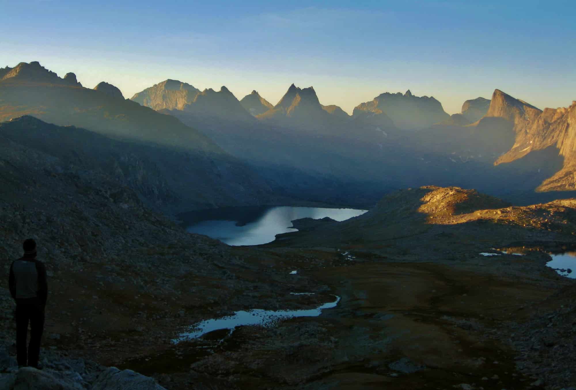
Sunrise from Photo Pass, overlooking Bewmark Lake and the Middle Fork (Skurka caption)
Permits
To show my respect to this land’s native inhabitants whose way of life my ancestors annihilated, I OF COURSE carried a permit. This is the very least I can do as a visitor. For every soul, culture, and lands lost, for all that “The Res” means, I moved through their ancient home with humility and reverence.
We picked permits up at Crowheart Store on our way from Dubois to Lander. It’s at 8526 Hwy 26. (307) 486-2285.
You’ll most likely pay $30 total. You’ll leave with a small stamp — ours said “2016 WRIR Recreational Stamp, exp 12/31/16, $5.00”. And you’ll leave with a slip of paper “Non-Resident Wind River Indian Reservation Tribal Fishing License” with these payment options: Annual Permit $120, 1 Day Permit $25, 7 Day Permit $75, Senior Citizen Annual (60yrs) $60, Youth Annual (15-17yrs) $25, Handicap $20.
We were in the 1 Day category, and it got a little complicated because they needed to record the exact day we’d be on their land. Luckily, they understood we couldn’t pinpoint the exact day, so they worked with us on that.
South Fork
“Climb steeply up to the hanging valley above.” “Tundra + krumholtz, avoidable willow.” Yikes. We sure would have liked to have avoided the willow. We ascended the east side of Bewmark Lake’s outlet stream as the map suggests and man oh man did we contend with willow (and a layer of krumholtz near the top). It was steep. It was thick with willows.
And an added insult — The Brawn unknowingly stepped on a wasp (?) nest. Those buggers were mad. They swarmed his face and nailed him, sting after sting after sting. He flailed around like a blind lunatic, spinning and swatting and shrieking (in a Brawnly way of course), and I’m standing only a few feet away, totally unmolested, pleading with him to be careful, don’t fall, don’t fall. It was a scene of intense insect revenge…and a swollen painful face once in the tent for the night. Anyway, good on you if you climb up to Bewmark Lake avoiding the willow — I wish your route could be blazed through there for the rest of us.
Consider NOT trying to follow the mapped trail along the west side of Bewmark Lake. I tried, in the predawn dark, to find this trail, couldn’t, got kinda obsessed (reason? your guess is as good as mine), so zig-zagged up and down the slope. Ridiculous choice. As the world woke up I looked longingly down to the lake’s shore and pined over what a sweet little park-like walk it would have been down there. An easy stroll is a rarity on the WRHR and I was bummed to have missed it.
While standing on Photo Pass, ID’ing “point 12,230” and its ridge that drops down to the NE was the landmark that helped us stay oriented as the day progressed.
Navigating from “PR-27” to just below “Last reliable water for 4 hard miles” was the trickiest and most rewarding navigation challenge of the trip. We*had*a*ball* with it. That doesn’t mean we got it on the first try, but our mistake gave us something to laugh at and learn from.
There’s nothing like being fully engaged with your surroundings, methodically looking for clues, accepting the lack of forward progress, and keeping positive. After we got on the right track, I ended up seeing the map-landscape-relationship the clearest, so I led, and as such, that section was one of the highlights of the trip for me.
Just keep following South Fork Bull Lake Creek south until you see the itsy bitsy “handrail” brook emptying in from the west. Don’t be tards like us and turn around spitting-distance too early thinking you’ve gone too far, only to walk a tangent to the handrail brook and wander around bewildered, up and down through the woods looking for it. Two hours later, I don’t think that brook has ever made 2 people laugh so hard. Btw, on our extracurricular tour through the forest, we saw “cairns” scattered all over. I’m not sure what they were for (placed by hunters maybe?) but they didn’t seem to be marking a linear route.
A daily concern at the forefront of my thoughts was where it would or wouldn’t be possible to pitch a tent that evening. You can’t tell from the maps, lemme tell ya. There’s just so much talus everywhere. So Skurka’s comment “The tarn at 11,000 feet is surrounded mostly by rock. Interestingly, there is more tundra a few hundred feet above” made all the difference. Tundra was the siren song in my head that day.
Skurka’s “Last reliable water for 4 hard miles” warning threw me off. I carried wayyy too much water up Europe Peak. I think his comment should be disregarded. These miles were actually easier than most of the route, and there was scattered water on the broad ridge that you descend after leaving Europe Peak. Plus, crawling up the chute (aka “15-ft Class 3 corner to knife edge, yeehaw!”) without superfluous liters of water is a safety consideration.
That first in-your-face view of Europe Peak after cresting “the saddle between points” is what high routes are all about. Just magnificent. And we get to go up there? Yes please!
Europe Peak
Looking back on our pictures from that first view of “the south face of Europe Peak,” it’s cool to notice that you can totally see the route. But at the time, of course, we had no idea that was the case so just read our map carefully and followed Skurka’s input and stayed on “climber’s left”.
This line could also be described as ascending just to the right of the literal jagged-edge-drop-off of the mapped Continental Divide. You do indeed “eventually reach the base of a moderately sloped 15- or 20-foot slab with good handholds on the right side; it’s in a corner and not airy.” By staying on “climber’s left,” you walk up directly to its “base”. I wouldn’t call it a slab though. I registered it as a nearly vertical chute equipped with hand and footholds galore.

The class 3 scramble that leads to the knife edge that in turn leads to the summit ridge of Europe Peak. Good stuff. (Skurka caption)
And yep, nothing was airy. Except when you top out of the chute onto the “knife-edged ridge”, which was fun and easy. But, the wind had picked up something fierce the night before and blew with wild abandon for like 2 days straight. I’m talking blow-the-food-right-off-your-spoon. I had to brace so it wouldn’t push me over the edge (hey – one good use for a heavy backpack).
Skurka’s data did a perfect job helping us navigate safely and efficiently up to the summit of Europe Peak. We really appreciated his clear route description because the terrain immediately surrounding the “climber’s left” route was steep and sketchy looking.
And we really appreciated the clear visibility we had from the top of Europe Peak. That was the other daily concern at the forefront of my thoughts: what if we lose visibility? How will we navigate? That thought had my stomach in a knot for the majority of the trip. Nope, no one can accuse me of having been ultra-relaxed about the weather’s potential impact on our ability to navigate on the WRHR.
Gannet was obvious from the summit thanks to the ribbon of white wrapped just below its peak. Being able to pick out the rest of the peaks Skurka mentions would have been super cool, but the wind cut our effort short. Since we wouldn’t let it whip the Earthwalk Press map out of our hands, it was like fine, shall I just shred it at the creases? Seriously. My wish would be for someone to take a north and south photograph from the top and then label the peaks on the photo. If that project appeals to someone, please send it my way. I’d be grateful and think you are the best, the cleverest, ever!

Looking north from Europe Peak. Golden Lakes is in the shaded valley, center-right. Gannett Peak has the horizontal band of snow across its summit. (Skurka caption)
Golden Lakes
Our pacing didn’t “sets you up for a camp at Golden Lakes” but camp we did, at a luxurious 1400 or some such crazy hour. The compromise for the trip was, if we were going to follow a described route, The Brawn would get to fish hopefully every day. Pre-trip, doing a described high route through the Wind Rivers was really unappealing to him. His dream, since he first went to the Winds at age 4 on a family trip, was to come back, explore around with a map & compass, and fish and eat his way through the mountains. But following a proven, best-of showcase thru-route between the range’s extreme southern and northern 13ers was a match made in heaven for my goal-oriented, geomorphological-inspired style. So we compromised.
I got to babysit camp and read all afternoon while he fished – another match made in heaven. Meanwhile, under an evening sky streaked with pinks and lavendar, when the chill told him it was time to wrap it up, The Brawn caught and released his first fish in the Winds 49 years after spawning the dream. He came back to camp giddy as a boy, snuggled into his bag, and spun me a fishing tale. Sweet, sweet Golden Lakes, thank you.
Thanks also to my fisherman Dad, who too was smote with the affliction at an early age, for encouraging the effort by putting his snazzy pole and reel in The Brawn’s hands and constantly bringing the subject up both pre and post trip. To the Parent Supporters of Adventurers: your interest in, sharing of resources with, and playfulness of spirit bowl us kids over. You have our mad love.
Douglas Peak Pass
Mad “intimidating” was our first impression of “Douglas Peak Pass”. We went through all the stages of WRHR shock: incredulous, dispirited, analytic, faith, acceptance. A recording of our balking and blabbering while working through the 5 stages would be priceless. Thanks, Skurka, for an opportunity to follow your course on faith alone, because from a distance, it looked impossible (or impossibly dangerous). Our faith in you had been building all trip thanks to your clear, tested, trustworthy route descriptions, so why lose confidence now?
Standing down at “PR-34” and looking up, you truly can’t imagine that the route goes, but once you’re up there, and it takes trust in your guide to go up there, you see you’re in the hands of an A-class guide. It’s such smooth sailing following “the strip of green” (compared to what it looked like from below) it’s like a magic trick.

On the magic strip of green below the east wall, on the way to Douglas Peak Pass (Skurka caption)
This is also the place where I really noticed a big difference in my reaction to sketchy terrain (loose talus, steep exposed slope). It wasn’t a very big deal anymore. The other thing that wasn’t very big anymore was my pack. Sorry for hammering so much on this point, but do yourself a favor and tackle this terrain with as light a pack as you can manage. If the extra effort of resupplying sets you up for a fun and safe passage from the beginning, it’s soooo worth it for this thru-hike. I didn’t know better, but now you do!
Corrections: “there’s a stunningly good route (relatively speaking) at the base of its east wall, following the strip of green.” The mapped route hugs the base of its WEST wall. “You’ll have to get around cliffs that guard the lake’s west shore”. It’s the lake’s EAST shore.
Alpine Lakes
“Four miles away and at least as many hours” – it doesn’t look like it should take that long, but it sure does. We appreciated the head’s up – helped with expectation management.
Once you reach the foot of the last lake (11,335) before Alpine Lakes Pass, the going gets slow. You’re basically side-hilling a ginormous loose moraine loaded with big boulders you don’t want to have come down on, or out from under, you. Parts of it felt like I was engaging in risk-taking behavior, but at a level of risk that was still within the sane-range (as opposed to me and my pack meeting West Gully).
Here’s what I mean – my impression was that the unconsolidated glacial debris you’re traversing could shift and an unfortunate accident could happen despite a person’s best efforts to move with caution.

At the top of Douglas Peak Pass, looking north into Alpine Lakes (Skurka caption)
Kudos to Skurka for his thorough three-paragraph description to help get you safely past lake 11,335. That area would be tough to describe in a guide. We did lose track of what he was talking about a bit, but we kept trying and his instructions did help.
“Since contouring across loose talus is not particularly safe” – I second that. It was actually in the Alpine Lakes Basin that I really settled into my style to walk an extra zig-zagged distance just to stay off higher-angled talus or moraines.
Just an aside. There were so many people in Alpine Lakes Basin, and they were all reporting on the man+dog we ended up camping with that night. The man+dog had become separated from their 2 companions the day before. Neither he nor his dog was injured and, except for a broken hiking pole, he had a full complement of backpacking equipment. That afternoon, an unrelated group gave him their SPOT so he could signal in the emergency – his companions didn’t have maps and he was concerned for their welfare. We helped him wave at the helicopter that made a few passes over us just before dark. We all went to bed not knowing what the next step would be, and The Brawn and I took off early the next morning before any new developments.
The view from Alpine Lakes Pass was something. Knife Point glacier is so neat to see, although sadly it seems to have melted back even further from Skurka’s blue mapped dots. I remember standing in the 27F shade up there, with all my clothes on, still shivering and numb while trying to match the new terrain to our maps. It’s hard to be diligent, sit still and focus, and use a high point for a navigation opportunity when you’re so cold. But then I counted my blessings that the skies were clear for us to navigate at all.
Point 11,385 north of us was the key feature we picked out to help us navigate for the next couple hours. It would have been obstructed from view in the type of weather we encountered in the Cirque. I shake my head even now thinking about what it would be like trying to navigating in the middle of the Winds with poor visibility. Yikes. Incidentally, we got another taste of that the next day.
North Fork
No ford was necessary of North Fork Bull Lake Creek; it was easily rock-hopped. Here’s another dose of expectation management: travel from Alpine Lakes Pass to approximately “Use tr E of talus, to the floor” is saallloooowwwwww. OMG. Hello freshly exposed glacial debris. If it helps, remind your head to just go to your happy place, and your knees to hang in there be strong this won’t last forever you invincible wonderful all important shock absorbing hinges jeez I love you and man I’m so sorry.
“By an 11,100-foot notch” – this area is a walk in the park compared with the maze of rubble you just hopped across – grass, krumholtz, even an elk to go along with all the sign we’d been seeing. We studied our maps at “5-star views, including of Blaurock” and had a heck of a time distinguishing between Blaurock Pass and Backpackers Pass. I was convinced our target was Backpackers Pass, and the sight of it didn’t instill confidence. It looked gnarly. We sat there and grumbled. So we kept orienting, and finally made the landmarks fit to where Blaurock Pass is (one pass over to the right from Backpackers Pass, thank goodness). Again, the thought of poor visibility made me ???
We didn’t have to ford the milky North Fork. It took a while though. We’d choose a promising spot, rock hop to the middle of the creek, but then were repeatedly turned back by only one darn rock-hop-leap that wasn’t worth taking the risk for. We ended up crossing higher upstream (but not at all as high as “above the floodplains”) by both rock hopping and jumping across smaller channels topped with willow.
Concerns about navigating in poor visibility caught up to us the morning we woke to ascend Blaurock Pass. We were camped at its base, just a step up from the floodplains. It was socked-in, raining, hailing. No visibility starting maybe a couple hundred feet above us. We could have ascended, but it wouldn’t have been worth it because we were counting on the view from the top of the pass in order to navigate to our next destination. So we stayed in the tent. Several hours later there were some brief views of the sky, so we went for it. Good decision – the top was open for orienting business.
Phew, getting up to the top was a little sketch in one place. We decided to go up the rocky outcroppings on the right (east) and that got a bit interesting. Pretty steep. Gave each other a helping hand in a couple places while trying not to knock loose rocks down. Next time I’d for sure stick to the gut. I noticed that about myself, and I finally learned the lesson once and for all on Blaurock Pass and broke the habit. Up to that point, if the sides of a pass looked more stable, I’d head over there, but would always regret it because it would get steeper and looser than the terrain right up the middle.
We were laughing that we made Blaurock Pass into a “Class” 3 experience – but truth be told it was a worn-down laugh cause we were mentally and physically wrung-out by then. The Brawn’s knee was markedly swollen, we were cursing the joint-abusing up down up down nature of the jaunt, and, despite rationing, we barely had any food left.

The view of Gannett Peak and the Dinwoody Glaciers from Blaurock Pass (Skurka caption)
Dinwoody Creek
Correction: “The northeast ridge of Pedestal Peak…right of which is PR-45.” That should read “PR-47”.
We “scrambled down the slabby nose” and had fun with it. But backing up a bit…
While we waited out the bad weather in the tent that morning, I knew one of us had to be a cheerleader/motivational speaker (The Brawn couldn’t put his full weight on his swollen knee, so his travel was getting slow, painful, and unsafe), so I spoofed a tale about us accepting that we were, for all intents and purposes, walking through a mural called insanity. It worked! That mindset made us both accepting and detached. It was like we became outside observers, and things that were a ridiculous struggle before became ridiculously funny.
We were also pretty calorie deprived. As we weren’t making the 10 miles/day for which we had budgeted, and The Brawn had yet to feed us fish, we had been rationing. And the physical effort expended up to that point easily surpassed our meager daily rations. So I think we were a bit strung out. But as is the custom of any Continental Divide thru-hiker worth the salt staining their shirt, we looked it straight in the eye and embraced it (shout out to D-Low).
Back to the “slabby nose”. It was another bonding moment of the trip helping get The Brawn, with ½ of his walking mechanism shot to hell, safely down. That was also where we both used micro crampons for the first time. Oh they were a revelation. How fun. Just as I wondered where hiking poles had been on our HDT adventure, I wondered where micro crampons had been my whole life. Don’t answer that.
“PR-43 | Preceded by wet ford” – We didn’t get our feet wet. After searching around a bit in the upstream direction, we found a narrow spot that some kind soul had jammed with a piece of wood. I’m pretty sure a use trail led to it.
Tags: Spiderwoman's WRHR Tips, Wind River High Route