Scheduling Considerations

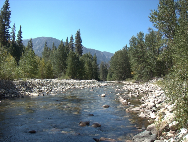
The Middle Fork of the Kings River at Simpson Meadow, September of 2014, a drought year. It was barely deep enough to bath in, but imagine when the river is up to is banks during peak spring run-off.
Besides personal factors, the feasibility of a Kings Canyon High Basin Route thru- or section-hike is driven most by:
- Snowfall during the previous winter, and the
- Monsoonal weather pattern.
Bug pressure, daytime and nighttime temperatures, and daylight hours may also be important considerations, but they do not have the same potential to be deal-breakers.

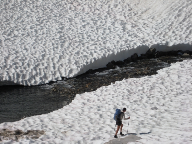
Typically early-summer travel: lingering snowfields covered in suncups, melted-out snow bridges, and high water. Oh yeah, thick mosquitoes and intense sun exposure, too.
Snowfall
Throughout most winters, the High Sierra is clobbered by Pacific storms that drop hundreds of inches of snow at the higher elevations. In contrast, the summers are very dry. The Lodgepole weather station, for example, records 87 percent of its annual precipitation in the six months between November and April. It sounds remarkable, but it is true.
Snow depth in the High Sierra peaks around April 1st, on average. Prior to this date, more snow accumulates than melts; afterwards, more snow melts than accumulates. As April 1st approaches, predictions about the cumulative winter snowfall can be made with more certainty. Will it be average, below average, or above average? If below or above, by how much?
Runoff from the melting snowpack normally peaks in June, when temperatures are finally high enough at the highest elevations, where most of the snow falls. After heavy winters, runoff can remain high later into the summer, since there is more snow to melt and more groundwater to discharge; after light winters, the opposite is true. For flood forecasts and streamflow data, consult the California Nevada River Forecast Center.
The Kings Canyon High Basin Route crosses several creeks that will be hazardous in early-season conditions, notably Bubbs, Woods, South Fork, Palisades, and — the biggest of all — the Middle Fork at Simpson Meadow. In addition, high runoff may force you to stay on one side of Disappearing Creek in Enchanted Gorge, instead of crossing over when there is better travel on the other side. High-water options (e.g. alternates routes or trails, nearby bridges, sections of calmer water) are noted in the Kings Canyon High Basin Route Guide, but they are unlikely to be as convenient and they still may not be viable.
There is a second snow-related hazard on the KCBHR: lingering snowfields. There are some instances when I love hiking on snow, especially if it spares me from nasty talus or loose sand and gravel. But overall snowfields make for more challenging conditions. First, most snowfields in the High Sierra become badly pockmarked with sun cups, which are tedious to walk on. Second, vertical or overhanging cornices may block access onto or off of a snowfield on the leeward side of a ridge or summit. And third, snowfields at higher elevations and on north-facing aspects can harden overnight, increasing the chance of a fall, the consequences of which can be significant.

Typical weather of a monsoon event: reduced visability, rain/sleet/hail, dropping temperatures. Windy Ridge looking over the Middle Fork.
Monsoon weather
The prevailing summertime weather system in the High Sierra is the North American Monsoon, which normally picks up in early July and fades in September. This pattern also affects Colorado, Utah, Nevada, Wyoming, and especially Arizona and New Mexico.
Intense solar heating of the southwest US allows moisture from the Gulf of California, the eastern Pacific, and the Gulf of Mexico to flow into the region. This moisture first manifests in puffy, cottonball-like cumulus clouds that build throughout the day, peaking in size and quantity in late-afternoon before dissipating in the evening hours. Cloud development is often greatest over high land masses, which forces the moisture upwards into colder air.
On days with early build-up of cumulus clouds, afternoon thunderstorms are more likely, and sometimes inevitable. Lookout for a dropping cloud ceiling and dark, vertical cumulonimbus clouds with an anvil cap.
Monsoon thunderstorms are often violent and dangerous. A lightning strike is the risk with the highest consequence, but the odds are relatively low. The more assured risk is exposure, which can lead to hypothermia. The thunderstorms drop torrential rain, and sometimes hail or snow. And the ambient temperature drops suddenly and significantly, since the dry High Sierra air has little thermal mass to counterbalance strong downdrafts of cold air from thousands of feet above.
In addition to lightning and cold-and-wet conditions, thunderstorms can also cause a loss of visability as low clouds engulf the mountains.
The KCHBR is often in high and exposed terrain, the last place you want to be during a thunderstorm. Additionally, off-trail navigation is very challenging and possibly dangerous when visability is limited, even if you have a GPS: it may tell you exactly where you are and where you need to go, but it cannot identify an optimal or safe route to get there.
Ideally, your trip will not coincide with an active monsoon pattern. And it probably won’t — blue skies and sunshine dominate the summertime skies in the High Sierra, and the monsoon season is not nearly as fierce as it is in the Four Corners states. Unfortunately, the monsoon pattern can only be predicted in a 5-day forecast.
But if it does, you may need to adjust your daily route and/or itinerary. First, utilize fully the morning hours, when thunderstorms are least likely, so that you do not fall badly behind if your afternoon is unproductive. Second, identify alternate routes that will be more feasible during a storm, i.e. lower in elevation and on-trail.

Enchanted Gorge and Disappearing Creek, down which the KCHBR drops 6,000 vertical feet to the Middle Fork
Scheduling recommendations
On average, I believe that September is the most reliable month for a Kings Canyon High Basin Route thru-hike, and to a lesser degree for a section-hike. By then, water levels are low and the monsoon pattern is less active. In addition, mosquitoes will be few or non-existent, and daytime high temperatures are perfect. There is less daylight in September than the other summer months, but still enough — about 13 hours on September 21.
But September is not even guaranteed. An active monsoon can still prevail, or an early Pacific snow storm could hit, especially later in the month. Unfortunately, such events are not predictable months out. Therefore, if you have the flexibility in your schedule, my general recommendation — regardless of the month of your hike — is to block out more time than you actually need, and then start your trip as soon as the short-term forecast looks accommodating.
August is the second best month. Water levels will be higher than in September, but most fords will still be easy, except for perhaps the Middle Fork at Simpson Meadow, especially after an above-average winter. The monsoon may be active, or not. Mosquitoes will be present but manageable. The combination of warm daytime temperatures and intense solar radiation can be tiresome, but at least the mornings and nights are very comfortable.
I would discourage the scheduling of a KCHBR thru-hike in June or July. In June, lingering snowfields at high elevations will complicate travel. In July, the mosquitoes and the monsoon will both be more active. But the most serious issue during these months is high water. Consider that the KCHBR fords are generally downstream of those on the John Muir Trail, and way below those on the Sierra High Route. In particular, the Middle Fork at Simpson Meadow has several times the water volume as any ford on the JMT or SHR. High water and delicate snow bridges in Enchanted Gorge will also be problematic, and especially dangerous for a solo hiker.
Of course, these recommendations are generalizations based on average conditions. But in reality in these conditions change by the year, month, week, day, and even time of day. Also, there is a personal component, too. A backpacker with extensive fording and snow-travel experience may not blink at the conditions in July, whereas another backpacker may still not be comfortable by August.
I have mid-June to mid-July available for a 100-200 mile hike, not optimal for high Sierra due to snow/snowmelt. Can you recommend something in another location or state? TIA
The High Sierra would not be unreasonable if it remains dry this winter. Right now the snowpack is only about 50 percent of normal.
The San Juans of Colorado normally melt a little bit earlier than other ranges in the Mountain West. Sangre de Cristo, too, though it’d be hard to hike 100-200 miles there.
Is the first of July still too early to start this year? I know the snowpack was low this year?
Go for it. In early-July 2015 after a similarly dry winter, I did the entire route and a lot of the alternates. I encountered a little bit of snow on Longley Pass (easy to get around on the rocks to the north), but I think that was about it. Not even any snow in King Col.