Primary Route + Section Hikes

The Great Western Divide as seen from below Deerhorn Saddle, an alternate route
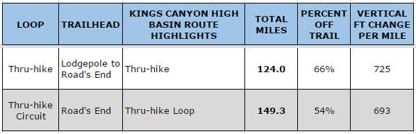
The 124-mile Kings Canyon High Basin Route can be completed as a point-to-point thru-hike, or as a closed loop with the addition of 25 trail miles. Alternatively, shorter segments of the KCHBR can be completed as section-hikes.
The number of miles you should expect to cover each day is primarily a function of your fitness and the amount of off-trail travel on your particular route. If you are considering the KCHBR, presumably you know about how many miles you like to hike each day when on-trail. The off-trail miles will be slower, perhaps much slower. If you are an excellent navigator and are comfortable when scrambling or hiking on uneven surfaces, expect to slow by 25 percent plus/minus. At the other end of the spectrum, I have seen veteran backpackers maintain just 25 percent of their normal on-trail walking speed when off-trail. Not sure how you will fare? Start conservatively with an itinerary that should be well within your ability and time allowance.
Primary Route
A complete thru-hike of the Kings Canyon High Basin Route between Lodgepole and Road’s End is 124 miles. To simplify your travel logistics, budget enough time and food to hike an additional 25 miles on trail in order to make a full loop.
Section Hikes
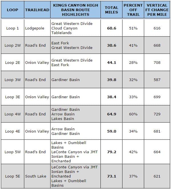
The KCHBR can also be section-hiked. In the Kings Canyon High Basin Route Guide, there are nine specific itineraries, ranging from 30 to 80 miles. The section-hiking opportunities are hardly exhausted by these prescribed routes, however — given the number of trailheads, trails, and off-trail routes in Sequoia-Kings, the options seem nearly infinite. Rather than go down that rabbit hole, I stopped at nine since the entire route was covered and since there was a good range of mileages.
Was on section of Route this past week and hiked to top of Kings Col for decent and it was unpassable. Way too much snow. We descended via Kings Col central instead. That was ok but the brush and bushwhacking getting down to Woods Creek was ridiculous. Beautiful out there but I think due to large winters the past few years have caused a ton of brush growth. It was a tough go for sure. Good luck out there. Enjoy and be safe. God Bless!!!
If you descend King Col Central, I think the better thing to do is jump the eastern ridge into Col Creek, which is an AWESOME slab descent and way less brushy than the drainage just to the west that you came down.
Was King Col totally plugged up, side to side? Or was the headwall just to steep? Any additional description would be useful, besides simply impassable.