Let me sound old for a minute. When planning the Sea-to-Sea Route in early-2004, I relied on USGS 30- x 60-minute paper maps at 1:100,000 scale to plot, measure, and follow a 700-mile route across North Dakota and Montana to link the North Country and Continental Divide Trails. Two years later, when planning the Great Western Loop, I was thrilled to discover the relatively high-tech National Geographic TOPO! software, in which I could digitally create another 700-mile route between the Grand Canyon and Pacific Crest Trail and then print custom maps of stitched-together USGS 7.5-minute quadrangles. Rounding out my navigational toolkit was an altimeter watch and magnetic compass.
(If I was a real old-timer, I could tell you about mail-ordering quads or sifting through drawers of them at my local outdoor retailer, or even using a sextant, but I just missed out on that.)
With paper maps and TOPO!, I was able to get it done. But by comparison the modern backpacker has a bounty of more user-friendly and more feature-rich mapping and navigation technologies, including Gaia GPS, AllTrails, Guthook, Backcountry Navigator, and others.
Long-term review: CalTopo
My own platform-of-choice has become CalTopo, and I think it’s now the clear winner for those who have similar needs.
- At home, I use the CalTopo website to plan personal and guided trips — specifically, to measure distances and vertical, insert helpful annotations, and draw in unmapped trails and routes;
- Also at home, I use the website’s print feature to export multi-page print-ready PDF’s that I carry into the field; and,
- In the field, I use the CalTopo app to help me navigate (via GPS) and as a backup map library.
The website and app are synced in real-time (or when the phone has a connection again). So when I edit an existing map or create a new map on one device, it updates to the other. I need not export GPX files (or similar) between platforms — it’s an all-in-one solution, desktop and mobile.
A subscription is required, ranging from free to $100 per year, with most users probably being content with the Mobile ($20/year) or Pro ($50/year) levels. Personally, I have a Pro account, and if I dropped down I’d miss the printing options (11×17 paper and 300 dpi) and Sentinel satellite imagery, plus the parcel data during hunting season.
In full disclosure, CalTopo provides me with this Pro membership, and it also offers free two-month Pro memberships to my guided clients so that we can teach participants how to plan routes at home and to use a GPS app in the field. I wouldn’t get too skeptical based on this admission though — I use CalTopo nearly everyday, and if it wasn’t top-shelf it’d have to offer a lot more than “free” to get my endorsement.
CalTopo desktop
I transitioned to CalTopo in about 2013. TOPO! had been discontinued and was not compatible with the newest version of Windows, and I was increasingly comfortable with cloud-based services like Gmail and Google Drive.
At the time, CalTopo was just a website, and it was functionally comparable to TOPO!. But founder Matt Jacobs was constantly making upgrades — more tools, more map layers and overlays, and an improved file-saving and file-sharing system. It felt like a better product nearly every time that I logged on.

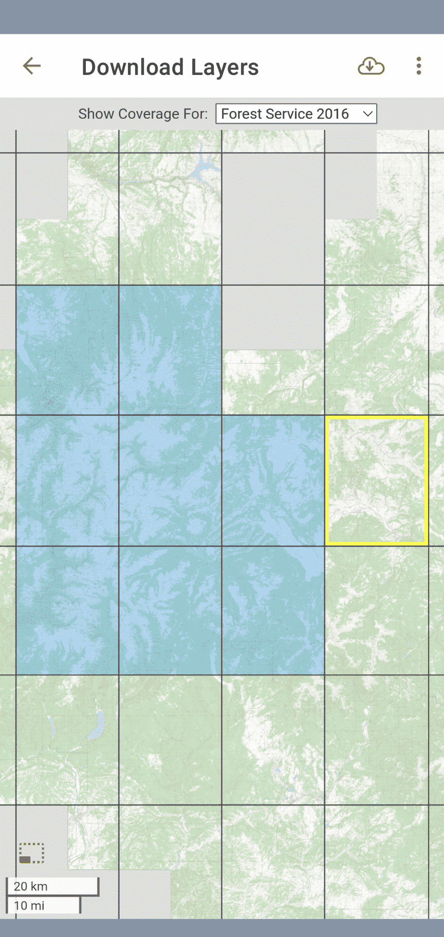
To plan custom routes and create custom maps, I add objects like markers and lines (both available in dozens of colors and styles), and organize these objects in folders. Lines can be snapped-to existing trails or created off-trail; distances and vertical profiles are available.
I can toggle between multiple map and imagery layers. Most often I use USGS 7.5-minute scans, the FS Topo 2016 map, and Landsat. But in the early-season, I’ll look at the Sentinel satellite imagey for current snowpack; during the fire season, I turn on the Fire Activity overlay; and just for fun, I like looking at historical topographic maps from the early-1900’s.
Once I’m happy with my map, I create a print-ready multi-page PDF of it using CalTopo’s print function, then upload the file to FedEx Office. Refer to my exporting and printing specs for more details.

CalTopo app
The CalTopo app was released in 2018, but until last season I continued to use Gaia GPS. CalTopo lacked aesthetic refinement and was missing important features, and I also just hadn’t taken the time to learn it.
But the CalTopo app has arrived — it now offers all the functionality that I need from a GPS tool, and it has a very intuitive system for downloading maps for offline use. Sealing the deal is its convenience: I can load and edit my maps at home on a desktop computer, in the field on my smartphone, or on my couch using a tablet.

My “guide map” for Escalante, pulled up in the CalTopo app An intuitive system for downloading map tiles for offline use.

CalTopo versus Gaia GPS
My recommendation for many years was to use CalTopo at home and Gaia GPS in the field, and have the platforms talk to each other by exporting and importing GPX files between them. The comparative strengths of each platform reflected their histories — CalTopo started as a website and later launched an app, and Gaia GPS started as an app and later built out its website.
However, I’ve now migrated fully to CalTopo for home and the field.
For route planning at home, the Gaia GPS website is functional. However, its print feature is a deal-breaker for me — it exports one-page PDF’s only. For those who use their phone exclusively in the field, this may be an acceptable ommission. But each year I print hundreds of paper mapsets between two and twenty pages, and it’d take hours to manually combine one-page maps into multi-page sets before sending them over to FedEx Office.
Less importantly, I’m not a fan of Gaia’s folder-based organizational system. I always struggle to create a dedicated map for an area or route that doesn’t get polluted by waypoints and tracks that I’ve created previously for other projects.
Lastly, I’ll add that I’m concerned about the future of Gaia GPS. In February 2021 it was acquired by Outside (formerly Outdoor Pocket Media), which also has purchased Backpacker, Trail Runner, Warren Miller, and VeloNews. Gaia will be part of its Outdoor+ subscription ($99 per year); for now it’s still available as a standalone app.
Will Gaia GPS remain focused, nimble, and innovative? Or will it fade into oblivion if its team is gutted (founder Andrew Johnson has already resigned), if its new owners fail to understand marketplace changes caused by new technologies or the competition, or if the parent company encounters financial difficulties.
CalTopo versus OnX Backcountry
This year OnX Backcountry has made a play for the outdoor market, partly by buying the loyalty of outdoor influencers.
Let me save its marketing team some time: Don’t bother contacting me. I’ve looked at the product, and it does not fulfill my needs. Also, I find it mystifying why multi-sport users (e.g. a hiker that also hunts, like me) need to buy subscriptions to multiple apps to get all the data that we want. In comparison, CalTopo and Gaia offer everything in one package.
CalTopo versus Guthook Guides
For popular (and, now, even not-so-popular) long-distance trails, Guthook Guides is the way to go. It offers trail-specific information like data charts, real-time water reports, and town services, whereas CalTopo has none of that (and no plans to add any of it).
If and when a thru-hiker graduates to more unique and adventurous DIY itineraries, which are not supported by Guthook, he or she should check out CalTopo.
CalTopo versus AllTrails
Around the same time that National Geographic discontinued TOPO!, it partnered with AllTrails, leading me to think that it had settled on a replacement.
But AllTrails had a different vision. It’s not a platform for power users who want to create custom routes and maps like TOPO! was and CalTopo is. Instead, its an extensive database of user-submitted hikes that other users can replicate, review, post comments about, and share photos of. AllTrails is a good resoure for beginner-level hikes and overnights, but it’s not optimized for endeavors more involved than that.
I’m new to CalTopo, but love maps in general, and have only browsed areas I know or plan to visit. Are there any tutorials, videos, or websites that explain not only how to create maps but what functions you are most likely to use or are most helpful. Then use that information for the take-along paper map. Also, how to download way points from CalTopo to a GPS device.
Try this tutorial, https://andrewskurka.com/assignment-create-a-topographic-mapset-with-caltopo/
To download your digital maps to a digital device, it’s best to use the CalTopo app, because it syncs with the website. So you have one cloud-based map, and you can access it at home on your computer or in the field on your phone. (When the app syncs, it holds onto the map data so that it’ll still be available when you’re offline. Then it syncs again when it has service.)
If you are really wedded to a standalone GPS device, which IMO are antiquated and no longer a best practice, then you can download your CalTopo map as a GPX file and then upload that file to your device.
On of my concerns w GaiaGPS and purchase by Outside is the privacy agreement. It appears that Outside will develop database of where we all travel and market accordingly .
Thanks Andrew for your thoroughness and honesty
Jim
Great review. Just had a look at the CalTopo website and found, to my surprise, that it actually has coverage beyond the US which makes it look interesting (I’m Spain). I still do an annoying three-app-dance (Garmin Basecamp because of its database architecture to consolidate all my data without duplicating lots of POIs etc.; Google Earth because of its photos layer, and free beats Garmin’s paid BirdsEye imagery; Gaia GPS on my iThingies and for its custom maps). Since I have similar concerns about Gaia GPS’s future and also don’t particularly like its folder approach, does CalTopo have a different (better?) approach for managing lots of data (trips past and planned, POI collections by area and topic, …)?
Your three-app dance can be over:
* Store all your data in CalTopo;
* Use any of the three satellite layers in CalTopo, including the same imagery displayed by Google Earth; and,
* Get public and proprietary topo maps on the CalTopo website and app.
Re organization…
* In CalTopo you create a standalone map, which you can think about like a file. You can create an unlimited number of maps with the Mobile or better subscriptions.
* Within each map, you can create folders for different types of data, and toggle on/off the entire folder or one-off objects within the folder.
* If you’d like to add data from one CalTopo map to another, you must download the data (I recommend the GeoJson file type) and then import this into your other map. To avoid having to do this regularly, I’d think about the types of maps you want to have before you get started.
How I organize my data…
I have different needs because I’m running a guide service and writing guidebooks. But I think some elements of what I do can be adopted for purely private use.
* For each trip, I created a dedicated map. In this map, I draw my route, make annotations, etc. If I have data from past trips that could be useful, I can import it in. Then I print these maps for field use. After the trip is over, I may let it remain a standalone map, or I may integrate it into a “master map.”
* For areas that I frequent, I have a “master map” or a “guide map” that is loaded with info about routes, water sources, highlights, etc. When I’m in the field, I update this file as I go, by adding new information and updating older information.
I name my trip maps by the date, e.g. 21-07 Yosemite. And I name my master maps generally, e.g. Master – Yosemite. This way, when I sort my maps by alphabetical order, they group nicely.
*
One app is what I’m after, and I’ll make sure to play around a bit with CalTopo. For me, custom WMS map sources are a huge advantage over WMTS-only Gaia GPS. Printing maps is much less of a concern.
Thanks for sharing your organisational approach. Your “master map” concept made me realise that a fair bit of what I dislike about Gaia really is me coming from (yuk-ky, buggy, clunky and apparently sunsetted) Garmin Basecamp with its underlying database architecture – and not making the best use of Gaia’s folders. Now, off to re-think my workflow…
It’s worth mentioning that Gaia has multiple layers that are available to the pro members. For instance, in British Columbia, the ever popular Backcountry Map Books are an optional layer.
Not familiar with that layer, but I can offer a likely equivalent in the US: the National Geographic Trails Illustrated maps, which Gaia also has. These are great small-scale overview maps, and I usually carry a paper version when guiding in order to give clients some perspective and to help plan any major reroutes.
If I don’t have the paper retail version, it’s convenient that I can browse it on the Gaia website. I find it less useful on the phone though — on such a small screen, it’s tough to gain that broader context; and the TI maps are not as detailed as the USGS/USFS quads and therefore don’t make for a good navigational map.
Am surprised CalTopo has not yet offered the TI maps as a layer (probably too pricey). I find that layer really handy on Gaia on my phone when in the field, it’s got great info and a nice ‘look’.
Just started playing with the CalTopo App based on this review, and wow, it has come a long way. I may switch to it from Gaia. Thanks for this review.
Another thing I should say about TI…
If you try to export the TI layer as a PDF, it gets knocked down in resolution badly, to the point of being unusable. I suspect this is required by contract, to prevent TI’s paper map sales from being undercut. Too bad, because it’d be really nice to have the option of printing out just a few 11 x 17 prints of the TI layer, rather than having to carry the heavier and unwieldy retail version. This would also be a cost-saver, because the TI maps are nearly $15 each now, whereas an 11×17 print is just $1.50.
I always appreciate seeing your long-term reviews, Andrew, and find good value in them. Thanks for taking the time to write this up. I had considered using the CalTopo app for this years trips but deferred to Gaia again because of my (incorrect) assumption that CalTopo’s app was still young and “immature” and thought I’d check it out next year. However, it’s great to see someone that works throughout year in the wilderness give it a full workout and give their opinion on it. It was very interesting to hear that Gaia was bought by Outside. I had somehow missed that and I would agree with your concern. I must admit though, Gaia’s new release of Offline Route Planning (Trail Snapping) is something I’ve been looking for in an app for a while and may keep me with Gaia. I haven’t checked to see if CalTopo has that feature but if it did, I think I may definitely give it a good look.
unfortunately, CalTopo’s mobile app does not support “Trail Snapping” on the mobile app yet. You can only do it on it’s website. I just checked:
see the text “This function currently works in the web app only, not in the mobile app.” inside the “Snap To” heading of: https://training.caltopo.com/all_users/objects/lines-and-polys#snap
I also found this:
> Is there snap to in the mobile app?
> Not at this time.
on https://training.caltopo.com/all_users/getting-started/faq
that’s the one killer feature that I still use the gaia app for in the field. I like to be able to draw a line between where I’m at currently and some arbitrary point to see how many miles and what kind of elevation profile I have until I get there. Or on a longer hike, to plan out the next day, I use it to come up with scenarios like “if I make it to that lake tonight, where could I realistically plan on getting to tomorrow if I only wanted to do about 20 miles and 4k of climbing.”
You’ve probably discovered this by now, but for the sake of future readers:
At this point in time the snap feature also works on the phone app, on a loaded-from-the-cloud map, while online and in airplane mode. I haven’t yet tried it on a map that I downloaded to reside on the phone.
Thanks for this Andrew, in Colorado the “COTREX” app has been extremely useful for me, but I’ll definitely have to fiddle with CalTopo.
Andrew, I think we’re around the same age and I fondly remember the map counter at the Berkeley REI from my high school years – they had a state map with each 7.5’x7.5′ quad marked on it, and a massive set of drawers holding all the actual quads. I’m not sure you get to write off sifting through drawers at a retailer as before your time.
Thanks for the review.
You’re right, if my backpacking trips were fast-forwarded five years, I would have been sifting through those drawers, too. But my earliest hikes were all on established long trails (AT, CT, PCT) or in really popular areas (NH Whites, CO Front Range) for which someone else had put together a map set or had published a functional overview map. In modern times, I would have been a Guthook and AllTrails user.
I remember those drawers and the quads.. still have a box full of old quads, folded mercilessly to display the areas I need in a rectangle that fits into a gallon ziplock (for water protection)..
Had a Gaia subscription but let it lapse, also not willing to join Outside+ just for that. I’ve used OnX for a year or so. It’s by far the easiest to use of any of the GPS apps. I was so so happy not to have to fight with the horrible Garmin interfaces anymore.
Caltopo produces the nicest paper prints though. Last weekend I had paper from Caltopo, and used OnX with a downloaded map a couple of times to check.
I do need to get the Caltopo app and see if it can replace OnX. The feature I use most OnX is the private land overlay, for figuring out fishing and other accesses. Presumably Caltopo has something similar but I haven’t found it yet. Thanks Andrew, gave me a push to go look now..
You want “Parcel Data.” It’s a toggle on/off layer for both website and mobile.
I’ve been looking for the impetus to replace Gaia GPS with the CalTopo app in the field, and your post may be it. While I like Gaia GPS just fine and have gotten used to it, it always seemed inefficient to have to create two sets of maps for my treks – paper maps on CalTopo and smartphone-friendly maps in Gaia GPS. But I am usually slow to adapt, especially when I invest a lot of time getting familiar with a new technology like I did with GaiaGPS (yeah, I’m old). I assume that the CalTopo smartphone app, like Gaia GPS, works fine without cell service as long as the maps are pre-loaded?
BTW, I still find AllTrails useful when I’m looking for day hikes in a new location. Kind of like Yelp for hikers.
Yes, you can download maps for offline use in the CalTopo app. I find its system more intuitive than Gaia’s.
Yes, it’s a lot more intuitive for sure, and it tells you what layers you are downloading and the sizes! I find that info invaluable.
Quick update: It appears CalTopo doesn’t provide snap-to-trail routing on the mobile app (neither Offline OR Online), which is a little surprising. Maybe this really is just a fringe use case and I’m one of the few that uses it? I do especially like Offline route snapping for mapping or finding distances along trails while offline.
The app doesn’t have snap-to (online or offline), but the website does.
In the scheme of things, I don’t think this feature breaks my argument. I think you could make a case that Gaia is still the better app overall, but it’s not such a better platform (or has such a clearer future) that you’re still being forced to use the Gaia app and CalTopo website, which had been the case until recently.
With this particular feature, as someone who generally in life prefers to be exact (“it’s 12:02pm right now, not noon”), my preference would have to have it. But I’ve done some comparison of tracing a trail exactly and un-exactly (like drawing straight lines in the app or using my fingers as a “measuring stick” on a paper map), and the un-exactly method gets you almost the same result. So it’s importance may not be as significant as you think.
Thanks as always for your timely information! Just cancelled the auto-renew on my Gaia subscription due to the above concerns and have wondered what to do instead. I’ve used the CalTopo-at-home, Gaia-on-phone combo, but it’s great to hear that you feel confident in the CalTopo app now, as well. I appreciate all you do!
Agreed. As I think it out more, I’m starting to realize that it is far more of a “nice-to-have” rather than an essential. Especially if paper is readily available, the primary tool and apps are only secondary resources. It’s just so dang easy to pull out the phone that is sitting in your pants pocket. Maybe I need to start putting my paper maps in my pants pocket and the phone in a harder to reach pack pocket. 🙂 Thx again, Andrew.
Considerations for a comparison to FATMAP? My ski touring piers have all switched over to this app, I’ve yet to leave Gaia but was considering a switch to the Cal topo app. Have you played with fatmap yet?
I’ve not used it. In fact, I’d never heard of it until this.
CalTopo doesn’t do much/any 3D visualizations, which are helpful for those not very skilled at 2D map-reading but which are more vulnerable to optical allusions and which are limited in places by lower quality Landsat imagery (e.g. Alaska’s Brooks Range). I see 3D as being as helpful reference, but less definitive than 2D contours.
Tools/data on the CalTopo app that are useful to backcountry skiers:
* Slope Angle Shading
* Avalanche forecasts (zone)
* SnoTel site data
CalTopo is sufficient for me for backcountry skiing, but I’m hardly pushing the limits of backcountry ski mapping — on the occasions I go out, my goals very very modest. Maybe another user can chime in.
As with the debate over Gaia, I think some of these app-versus-app comparisons put focus on an issue that really doesn’t drive the decision. With CalTopo, you get a more powerful at-home mapping platform than what is provided by FATMAP. And it’s pretty convenient to have that map synch over exactly to your phone, as opposed to importing/exporting files between platforms and apps.
I completely agree with many of the criticisms and concerns about GAIA, especially the clunky organization systems. And I am excited to see all the new functionality and slightly less wonky online UX of Captopo. But I have to say that so far in the field I keep going back to GAIA. It may just be a temporary coding hiccup, but for me, Caltopo gets stuck displaying various background layers while zooming. Hopefully they will work it out in the future. Next up: cross-platform interoperability with Garmin.
RideWithGPS has a nice trip planner as well.
Was pretty disappointed that Gaia GPS sold to Outside. They have already changed the privacy agreement and as far as I can tell they are using my personal data on the app. Don’t like that. But wasn’t sure where to go, and haven’t had the time to take on the research. I did try OnX and was very underwhelmed. So thank you for doing this writeup Andrew. Your endorsement is enough for me to give CalTopo a try in the field also, without researching all the options 🙂
thanks for the extra info! I’ve been using your old method to Caltopo and home and for printed maps and Gaia in the field but now I’ll try Caltopo for everything. Do agree about the clunkiness of Gaia sometimes.
Hey Andrew,
thanks a lot for sharing your information on mapping in remote places.
For me doing just hikes in Europe mainly in the alps the best solution still is mapy.cz! You can do all your mapping beforehand at the pc and then its syncronizes to all other devices.
There is a great app for mapy.cz for which you can download the maps for free, so offline mapping is there.
On top bike and car routing is also included.
I dont know about the maps outside of Europe, so maybe anyone likes to check that.
Just my 2 cents (sorry for the poor english)
Jens
Hey Andrew, I live and hike in Europe and here I use a service called FATMAP. It offers a lot of the features you have mentioned but tailored for Europe.
One really big consideration for me is the included map (or satellite or other) data.
I have noticed some pretty big differences between mapping software, and between locations, so I would say: “user beware”.
Gaia claimed National topographical maps for Austria for example, but when compared to other platforms, it was missing about half the information.
So before you commit to a platform, or before you travel to a new coutry/region, it is a good idea to check out what data is available for that location in your chosen platform, and especially compare it to others.
That’s very true – CalTopo is nearly worthless in the Alps, since they just use the OSM data anywhere outside US, and OSM can be downright dangerous to use in the Alps (e.g. ski-touring planning, OSM has big errors in slope angles and elevations that could lead to avalanche danger).
I can’t recommend a CalTopo subscription outside NA. There are much better local map sources for other regions.
I have been using Andrew’s old model (Caltopo for creating the maps, exporting the map to Gaia, then using Gaia in the field), and yesterday I did a ‘trial’ hike using the Caltopo app instead. I used the app for both navigating and tracking.
Everything worked very well, I like the more simple/intuitive Caltopo app interface (and of course the track/route organization, I hate the Gaia folders approach). As Andrew has mentioned, I found downloading the maps on Caltopo a lot more intuitive than using Gaia.
At least 2 things I do miss on the Caltopo app. One is there are no NatGeo maps. And secondly, I do like the ability with Gaia to download just their basemap for a big area, a very nice efficient way to have offline maps for a large area in case you are in the field and plans change (for example, I have all of Colorado east of Denver as a map on my phone, I think it’s around 1 GByte).
I need to spend more time with the app, I do not know how to do things like set waypoints, etc. But I really like just using Caltopo both on the desktop and on my phone.
Thanks again, Andrew, for all of this info.
I don’t have a history with the other platforms so I can’t offer a comparison, but I did just use Caltopo for two days canoeing the Current River in Missouri. (No cell service down in the river valley.) Loading markers for the different caves and springs was an easy cut and paste using coordinates from online sources. (I did it on my phone while walking my dog the night before my trip.) On river I dropped markers at our random gravel bar stops and was then able to estimate how much longer to the next point of interest.
Whew! Maybe it was easier when navigation technology consisted of always using scissors to trim the margins off my maps to save weight! (I became a USGS Map Dealer in order to save money on the hundreds I owned).
But I quit paper as soon as I could — and like you was very irritated when Nat Geo stopped supporting my beloved TOPO! (Lots of CD’s, but took up much less space than my maps.) Then I was an early adopter of the CalTopo – Gaia combo. So thanks for the heads up that CalTopo now does it all, and for the exhaustive feature review.
I wouldn’t be too worried about Outside purchasing Gaia. While we like to not like corporate acquisitions, they are often for the better, infusing resources into unsustainably small ‘doing it for the love of it’ operations. Users should consider the irony that their own annual income is likely much higher than that of the founders of the apps they use – and complain about when they are sold.
For the quick and easy app, like when I’m somewhere new that I didn’t have a plan for, I’ll often pull up one of the ‘Project’ apps, such as TrailRun, Hiking, and MTB Project, in order to become un-lost. They were purchased by onX and are are part of that larger suite.
When I’m going somewhere new and am wondering what to do, I’ll often look on fastestknowntime.com, because it’s a bucket-list of only the best routes rather than listing everything and anything (disclaimer: I’m a co-owner).
> I became a USGS Map Dealer in order to save money on the hundreds I owned
Another thing I have learned about Buzz. Love when you drop pieces of history like that.
Thanks for the review! I didn’t know you could look at current fires as a layer. That’s super helpful if planning anything out west. I use CalTopo on occasion, but as you noted AllTrails Pro works well if you’re just hiking or backpacking well-established routes. I do always use CalTopo to print out maps ahead of a trip. I haven’t found anything better for that. I’m getting by on the free version so far. I didn’t even know they had an app. That may get me to try it out for a year at the $20 level. Thanks again!
Yes, Caltopo is my favorite map app and I have been using it now for two years at the pro level. Actually I have a lot of fun using it. It took a little while to learn the ins and outs and while I was recovering from foot surgery for three months I mastered how to use it and You Tube helped a lot also. My senior hiking group which I lead here in the foothills of Auburn and our near by mountains are amazed at my expertized in my map making skills. I am right now planning my long distance hike on the AZT, which I had to abort in 2019 due to Plantar Faucitis, and using Caltopo and of course Guthooks maps as a guide. I turn 80 in February of 2022 and the 800 mile journey will be my gift to myself. Stay HEALTHY ANDREW and maybe when your 80 you can set the FKT on the AZT.
800 at 80, go Nitro Joe!
Curious Joseph, Auburn as in Auburn, Washington state? If so I wouldn’t mind joining the group and gaining some expertise. Please let me know. Thanks
California
I’ve been using CalTopo since 2013, enjoying it’s evolution from desktop to mobile app. It is my goto hiking app.
I’ve been using to map the shoreline changes since 2013 on a harbor of refuge on Lake Superior. Last year I used the fire activity layer to monitor the Cameron Peak and Troublesome wildfires approach my house, here in Colorado.
I’ve used the weather layers on winter trips, for snow info.
It’s the best that’s out there, in my book. Well worth the subscription fee.
Thanks for the review. I too have been using CALTOPO for about five years and watched it evolve and improve. I did go down the FatMap rabbit hole thinking that the 3D visualization would be a benefit for an off trail trek I was planning in the Winds. I was less than impressed and have let the subscription expire. Can’t wait to see what further tweaks happen down the road.
Andrew, I was surprised to see you say that the CalTopo map had improved. For me, it’s gone the other way.
The current version of the app on Android will not let me scroll through my very long list of map objects, so I cannot select what to display or hide. This makes the app completely useless. Has anyone else had this problem and found a solution? Every so often I reinstall the app to see if they have fixed this, but it’s been that way for many months. (When I first tried CalTopo a year or so ago, this bug did not exist. It was introduced later.)
I’m guessing that this bug does not exist in the iPhone version, and that you use iPhone.
I love CalTopo’s web site for planning at home and printing maps before a trip. Thank you for pointing me at this great resource. But on the trail, I use GaiaGPS with a premium subscription, and that’s not likely to change any time soon.
I use Android, and the folder window works just fine — I can scroll up and down to view all the folders, and close it out using the X at the upper-left.
I suspect that Matt Jacobs is subscribed to these comments so maybe he can speak up about this.
Thanks for that reply, Andrew. Now I’m scratching my head wondering what could be causing the problem for me!
I can open the Map Items folder list, select and deselect items, and close it with the X. But I can’t scroll through the list.
I can’t scroll through Map Layers either. But scrolling Display Options works as expected.
Scrolling the actual map display works fine.
This isn’t an issue I’m aware of. It’s likely limited to a few users, and specific to either your phone or your account data, or else we I’d expect we would have heard of it by now. Can you send a message to our help system (help.caltopo.com) including the phone model you’re using, so that we can work on debugging it?
Matt Jacobs,
Now that we have you here, do you have any update on when or if you plan on adding the “snap to” feature on mobile? Thanks in advance!
Unfortunately not. Best I can tell you it’s one of our top big-ticket items for the app, but that was also the case 6 months ago – it’s also one of those things that’s just enough work, it keeps getting bumped in favor of other high-priority tasks, which makes it hard to provide an accurate estimate.
Sure, thank you, Matt.
I’ve loved Caltopo since planning my 2017 JMT hike. I also used it for a walk down memory lane to recreate old pack trips from the 80’s and 90’s. The only thing keeping me from a paid membership is that I now live in Australia, and currently Gaia has a lot more content to offer down here than Caltopo. However, as you say, the Gaia desktop interface is miles behind Caltopo so as soon as the international content is beefed up I’ll make the switch.
So far I’ve been kludging together paper maps printed from Caltopo paired with View Ranger for my phone. Last time I looked at the Caltopo app it looked immature, but your review here may make me update my tools (again!). Thanks.
What kind of processing power (or video card etc) is required for running the desktop version. Also, can i “serve” that as a website on a WLAN? The SAR group with whom I volunteer operates away from the interwebs and I’d like to run many layers with various sectors, tracks and APRS beacons displayed.
I’ve been using CalTopo to draw maps and Gaia to read them for several years. After reading this article, however, I just upgraded my CalTopo account. I’ve got several trips coming up, so I look forward to field-testing. If all works well, I’ll delete Gaia.
A question: I’ve been toying with getting a GPS-enabled watch. Just for backpacking, not skiing, running, biking, etc. Mostly for keeping myself on-track, rather than route-finding. Can route maps created on CalTopo be transferred to those watches? Or would I be better off just keeping my smartphone handy? Thanks.
Watches make for really poor map displays. Stick with a paper map or your phone for navigation. GPS watches are good for logging things: distance, vertical, your track. Some reading, https://andrewskurka.com/navigation-system-equipment-watch-compass-altimeter-gps/
Thanks!
For about 6 months, CalTopo would not work on my iPhone, nor on my friend’s Android; in the field, the GPS worked, but no map layers would load. I should have contacted them sooner to fix it (I waited several months), but after someone initiated fixing the problem in the help forum, the company was very responsive and got the app fixed within a few weeks.
Just wanted to give a heads up to people that sometimes the app is buggy (which can be a safety concern if you aren’t good with map and compass). And if it is buggy, please go to the forum because you will be helped right away!
Andrew, since your blog has many international readers as well, perhaps you should specifically mention that CalTopo is only good for NA/USA use.
Many people do long hikes outside of that, anything from the Alps to Pyrenees or Scandinavia. US visitors tend to use CalTopo for them since they know it, but that’s wrong:
Outside of the US, CalTopo only use OSM data, just as the free OSM itself. The OSM data is notoriously unreliable in any mountainous regions like the Alps, with many serious errors in elevation, due to their licensing requirements and old and outdated DTMs – just look up iconic Matterhorn for an easy example of that – in CalTopo, there is a huge sinkhole there instead of a pointy mountain!
It’s usually best to use local maps for the region you are. In the US, CalTopo has access to official gov. map data, so it’s good. Outside of the US, not so much. For example, in the Swiss Alps, the official SwissTopo data is thousand times better. Likewise in Austria or Scandinavia.
Haven’t tried it, but CalTopo allows users to create custom maps from WMS and WMTS sources, see https://training.caltopo.com/all_users/base-layers/custom-intro#create
Using official (Swiss, German, UK…) topo maps should therefore be possible as long as you can figure out the tile URL scheme. Which is easy with a tool like https://tilejson.io or http://trailbehind.github.io/TilejsonTester/ (I’m in Spain, and I do it all the time with Gaia GPS).
Thomas, yes, that would be a possibility (although at the highest $100 tier only). Or using GeoTIFF or whatever formats are often freely available for download from some OpenData government geo sites, but that’s more of a GIS enthusiast territory 😉
Don’t take me wrong – I think OSM is pretty much great (it was certainly quite the online mapping revolution!), I quite like CalTopo & it’s neither’s fault that sometimes they just can’t use the better DTMs and other stuff from local providers because of just a slight license incompatibility. Copyright laws are quite a mess worldwide in the current distributed internet age – even when you aren’t running a crowd-sourced map portal…
I just wanted to bring to attention the possible issues of using only one source for any critical planning like ski-touring and slope-angle checking in some specific areas like the Alps, as it’s not that well known outside the GIS community – just look at copyrighting LiDAR data and previous DMCA takedowns…
I can easily imagine how some US reader (or even a reader from some other EU country) without any knowledge of GIS at all could think the data is all the same from reading the US-only reviews, using it for slope planning, when there might be better sources available (which – sadly – can’t be integrated into OSM yet due to obscure licensing issues).
Fortunately, more and more countries are releasing their data under fully permissive licenses, but it’s good to know about it – and lobby for it!
A small clarification, it’s not accurate to attribute any elevation errors to OpenStreetMap, as OSM does not maintain elevation data. Any OSM-based map source with shaded relief or contour lines is getting that data elsewhere, and it’s not always the same source – for example MapBuilder and OpenCycleMap do not have matching elevation data, even though they both use OSM for trails.
There are a few free global elevation datasets, all acquired from space, but there have been a number of different post-processing efforts to filter out bad data points, mix and match where each source is best, and so on, all with different results. You’re right that none of those results are “great”.
Where quality international data is openly available, we do try to incorporate it into CalTopo. Of the locations you list, Norway, Sweden and Finland have had scanned topos and reasonably accurate elevation data in CalTopo for a few years now. When SwissTopo released their maps under a more open license earlier this year, we added them to the scanned topo layer as well.
Unfortunately, unlike in the US, the work products of many foreign governments are not released into public domain as a matter of law. We don’t mind paying a flat rate, and have done so to acquire some layers, but we’re not setup to pay per active user (which would require tracking which specific users have viewed which map layers), which is what some foreign sources are licensed as.
Matt, thanks for the clarification, really!
I quite appreciate the very awesome work OSM or CalTopo has been doing for many years and I think I understand the previous license problems of using proprietary DTM data when something like OSM license – quite understandably – often doesn’t allow to use more modern data…
If anybody took my comments as a dissin’ any of the OSM’s or CalTopo’s work, well, it’s not. I quite appreciate what OSM, CalTopo and others have done over all the years, they have been great!
I just wanted to bring to attention that the licences are often incompatible with each other and what might be great for one region might not be the best source for another region…
Obviously, OSM data is evolving all the time. In the ideal world, all the gov’ DTM data would be released under a license that’d allow anybody to use it, including OSM. Unfortunately, that is not always the case. But as more and more local govs’ publish their data freely under something like CC, I have high hopes that it will change. It’s good to know CalTopo is following the trend.
On the topic of elevation, one thing I’m trying to figure out is cumulative elevation gain as I draw a line, or as I scroll through a profile of a long line I’ve already drawn. I’d like to identify when I reach daily total elevation goals. This would help me identify potential campsites just before or after where it lands on the map. Is this possible, aside from just splitting everything up into smaller lines?
You can eyeball it (eg “here’s a 2k climb, and this one’s 1k, and here’s another 2k”), but the only way to know total gain precisely is by measuring individual pieces and adding them up.
That’s what I figured. I notice it does show cumulative ascent in Gaia as you draw, but not when you draw and scroll after saving.
I experimented with drawing a bunch of different small routes (2k vert each) and also drawing one route while adding 2k waypoints along the way. I imported them into Caltopo (vert stats were within 2-3%), and I alternated the colors of the routes red/blue so I could see the longer easier sections and the shorter tougher sections on the overview map. I think I like the alt colors better b/c I don’t want to clutter the map w/ more waypoints than the ones I actually want to see and I can briefly name the lines by the total vertical up to that point (“16k”, “18k”, etc).
I’m still using both platforms so I have a backup GPS app on my phone, and probably to store past trips (the sharing between Coros & Gaia apps in an iPhone is easier than emailing gpx files to myself), to use Gaia if I ever need a the “guide to” function, and to supplement my planning as there are just some features/maps I like in Gaia better like the 3D view.
However, I agree… at home it is really nice to just view one map for one trip without having to hide other folders, and in the field I find myself using caltopo more because it just seems easier to use. The ability to draw a quick distance line or easily edit lines is huge when making contingency plans on the fly.
The GAIA subscription model drove me nuts. It just feels like they’ll take every opportunity to charge you for something. I’ve been a Caltopo premium subscriber for a while (I have a “Legacy” Pro plan). The added layers and added features over the years is impressive. Integration with Google Earth using the KML SuperOverlay is very handy and fun to use when researching new areas. The overall combination of available layers, ease of use, export / print / save functions are all second to none. I started using Caltopo when I wanted to save/export mbtile based maps to Alpine Quest. I’ve slowly started to move away from Alpine Quest as my primary phone navigation app and have started using the CalTopo phone app more. There are still a few features in Alpine Quest I really like (explorer mode and perspective view) but being able to create maps on the desktop and then save them for offline use directly on my phone with little effort is a great. Id like to see some additional tracking metrics added but maybe future updates will bring those.
I like how the CalTopo app draws a line out from your location/orientation so you can see what’s along your line of sight on a small screen. That’s a simple yet elegant solution.
The bugs in Gaia are just brutal though, so I’m looking at CalTopo now. They easily double my mental load with having to double check everything for silly issues and figure out what triggered what bug and how to get around it. I hope CalTopo is investing in a solid automated testing system for the app so it’s usable in the long run.
Nice review, jsut starting to look into this tool. Someone may have mentioned this, but what about more granular documentation of who owns land like OnX/Gaia, it has public land distinctions which is great, but add that feature and Caltopo would be the one to rule them all…
Caltopo has a Parcel data overlay which gives site address, ownership, parcel number & boundary information. It is part of the pro plan. Well worth the cost.
Ok thats pretty kickass, thanks!
Excellent review! You sold me on Caltopo!
My history of Navigation spans nearly 50 years and mirrors yours almost exactly. I decided to go “all-in” with Caltopo for many of the reasons you outline. I still rely mainly on map and compass navigation for off-trail hiking in the Adirondacks of New York and in Quebec but have grown to like bringing a device into the field for checking up on my position.
In winter if I use a device it will be a Garmin GPS, not a phone, so Caltopo will be used for route creation and transfer to the GPS, which has maps pre-loaded on a microSD card. After, if I have created a log I can transfer it into Caltopo for review.
This brings me to off-line use of the phone app, which I am experimenting with. I d-loaded a single yellow square (map layer = mapbuilder roads) of the area around my house in Laval, QC, which took quite a while for only 45 meg on my iPhone 7 (I thought it had stalled but then it showed up) . Depending on the zoom level the screen either goes blank or displays the streets in good detail. I can see that using this important (key, for me) feature effectively for an upcoming 3-month trip to WY and CO will require some playing around and real-life experiments here at home.
It seems that the CalTopo app does work offline (at least in airplane mode) without a paid prescription. Is this new?
Also, I’m wondering if there is any information regarding battery drain using CalTopo in the field
compared to say Trailforks, Avenza, Gia, etc. Especially in the cold.
My understanding is you are using the cache in the free version. You need to zoom in and move the map around on your phone in order for the tiles to d-load into your cache. This works well for a short trip but for multi-day expeditions I think having the tiles written to your phone’s drive is better. I’m experimenting with it currently (I got the $50 paid subscription.)
I have a brand new battery in my iPhone 7 (installed at an Apple store) and on a recent hike I ran Caltopo and recorded a tracklog. I started at 90% charge and my battery lost about 10% charge per hour. On another trip I had Caltopo up and running but did not record a track. IIRC the charge dropped about 5% per hour.
As a Search and Rescue volunteer, (and a geocacher) we have been extremely pleased with CalTopo, and their continued development. To be able to send an SMS message to a lost person and get their location upon their response and the ability to live-track our searchers in the field are fantastic features for us. Thanks for your precise comparison reviews!
Hi Andrew,
There are some layers that I really wish were in CalTopo, such as NatGeo Trails Illustrated and hunting related layers. Do you just go without those or do you keep a Gaia subscription for those?
The TI maps are excellent for route planning and big picture discussion, and that purpose I find the actual printed maps to be way better than the digital version. I stock every guide team with a TI map of their operating area (e.g. Sequoia-Kings), and they get pulled out when planning large deviations from the planned route, for evacuations, and to help clients see the forest through the trees.
Got it. And what about hunting related layers?
Turn on the layer for Public Lands. If you would like to hunt private land, turn on the Parcel Data layer; use the Ownership sub-selection to determine The individual or organization that should be contacted.
Thank you Andrew! 🙂
Just wanted to say thanks for the thorough review. I just found your site as I’m debating cancelling my Gaia subscription. I have a free Caltopo account and would rather pay them than Gaia at this point, assuming they are pretty equal. When I started Gaia definitely was better in the field but I’m glad to hear that I probably won’t miss it in the long run. Thanks for you time putting this together
Thanks for this. I’ve been a Caltopo user since switching away from Topo! software. Most recently, I pair with avensa for field use. I keep hearing about the newer sites/apps (Gaia, onX,
Etc) and when I briefly look at them, I don’t feel the draw that others have.
Your discussion has helped me to realize I can just stick with it…maybe I’ll even bite the bullet and pay for Caltopo, which I’ve considered for few years.
Andrew, do you have an affiliate link for caltopo,?
No. I don’t think they have an affiliate program.
Thanks for this review, as well as all of the content you’ve provided to help planning a safe trip in this record snow year.
Caltopo has been a game changer for me in looking at near-daily snow imagery in the Sierra for my planned July 10 JMT SOBO trip with my two sons. Being able to compare this year’s satellite imagery to 2019 and 2017 is really helping as we come up on our final go/no-go decision that will need to be made by the end of June.
I had been an Alltrails user and am very familiar with its limitations. I decided to switch over to Gaia GPS this year and did most of our JMT trip planning on Gaia, until I read this review.
I then decided to try Caltopo on our first of two planned shakedown hikes last weekend, and there are two primary issues that I had. First with with the mobile app, I felt the app (at least on iPhone) still needs refinement. The map display was glitchy on our hike, and I had to restart he app several times. Additionally, you’re not able to “pause” the track recording for extended stops (i.e. lunch break). Finally, I believe the app used much more battery life than what I’m used to. I usually easily get a full two-days out of my iPhone charge on a trip, and for this trip, I made about a day and a half.
Second, with the desktop app, I haven’t figured out how to easily edit a route once created. It seems that Caltopo creates literally hundreds of waypoints with its snap-to trail functionality, so when you try to edit that route, you have to pretty much start from scratch. I also found the route editing interface to just not be intuitive. I may be missing something here, but I wasn’t able to figure out how to easily edit a route that had been snapped to a trail, when it’s very simple on both Alltrails and Gaia.
So, I’m going to try the Gaia mobile app for my 2nd shakedown hike (a hopefully 7,000 ft elevation day in the Appalachians), and if that doesn’t work, I’ll go ahead with my familiar Alltrails for the JMT.
I totally get the value of Caltopo for more advanced off-route and expedition planning, and it’s definitely going to be a valuable tool in my toolkit even for on-trail trip planning. It’s just I think a few more refinements are needed for me to actually use it on the trip. I’ll also admit that there may be things I’m missing and the learning curve is just a bit steeper.
Thanks again for your posts!
Personally, I don’t track my route with the app. I do that with for sure with my Coros GPS watch (as it has outstanding battery life) and sometimes my inReach if I want family to know where I am. I keep my phone in airplane, and as I have improved my map and compass skills I’ve just opened Caltopo to spot check where I am or to verify if I have the right pass before I charge uphill. Sometimes my iPhone weirdly shoots up the brightness of the screen so I make sure that is turned down low and just in case that I have closed all other unnecessary apps.
In terms of editing, you have to Split the route into pieces, delete unwanted pieces, and then Extend the part where you want to re-route. You might possibly Join another piece of the route you split up too. I suggest renaming parts as A, B, C, etc so it is easy to piece them back together and to use a line with arrows so when you join pieces you know they are going in the same direction. As far as I know, Caltopo doesn’t have the “grab and drop” feature on a route line that GAIA does, but overall I prefer Caltopo. Even though there is a folder system in GAIA it is difficult to move things around and navigate.
I’d agree that the app needs further refinement. It’s functional, but not as pretty or intuitive as it should be by now.
To edit a route that has snapped to a trail, you could try Modify > Split, then delete the section you no longer need. Especially when I am just starting to draft out a route, I often avoid snapping-to so that my route is not by default given tens or hundreds of points that I may need to edit later.
Sure wish CalTopo would allow photos as waypoints similar to Gaiagps. As a professional Land surveyor, I use these extensively for surveying monument/control locations and conditions as well as campsites and POI’s. Ideas for any work around or ideas for handling these would be great. Also, I need the PLSS overlay…Unfortunately, CalTopo doesn’t offer it either. If it wasn’t for these two needed items, I would be with CalTopo.
It has offered this feature since May of 2024: https://blog.caltopo.com/2024/05/27/new-feature-photo-waypoints/. The implementation is still a little shaky—photos take a while to sync from the iOS app to the web, for example—but it’s useful.
I have used Gaia for years, and I just spent 3 days digitizing some long routes on GaiaGPS.com (I was logged in to my account and I saved, re-opened, edited, re-edited the routes and waypoints without any problems).
On the third day, a message popped up that “Gaia has updated. Please refresh your webpage.” I did; all of my work vanished and nothing I can do will bring it back. I’m fed up. If the developers don’t care enough about their customers to save their data when they release an update, then the heck with them.
I’ve switched to Caltopo (which I had use a little ages ago) and I’m pleased so far. The UI for mapmaking seems more professional that Gaia’s, closer to a real GIS program.
An addendum: Alex Brown, another experienced long-distance hiker, wrote a very thorough comparison of Gaia, Caltopo, and Onx Backcountry [here](https://thetrek.co/comparing-gps-platforms-for-hiking-and-backpacking). He wrote, “I stood by Gaia for a long time, but ultimately its stability issues drove me away. I have experienced complete device crashes, data loss, inability to load downloaded maps, and download continuity errors on several different phones.” Like you, he recommends Caltopo despite its rough edges…and I agree with you both that Onx Backcountry lacks some key features that any serious backcountry travel would require.
Great review, but I find CalTopo surprisingly unintuitive.
I’ve been using Open Route Service for years
https://classic-maps.openrouteservice.org
I use it both for hiking and cycling and always find the suggested itineraries superbly balanced between distance, difficulty, pavement type (in the case of cycling), distance from traffic (again more relevant in the case of cycling). Choose between walking and hiking or road bike and off-road bike really makes a difference and puts you on trails tailored to your specific plan. Creating routes by just clicking on the map to add waypoints and dragging the track if you are not satisfied with the suggested route is very simple. I’ll give a further try to CalTopo, but, so far, it feels like it does the same, just in a more tedious way.
I’ve used Garmin Oregon 600 and 700 handheld GPS devices for twelve years, and CalTopo for three or four years. I like CalTopo, with two issues:
It drains the battery in my iPhone 14, especially if it’s recording the track. Then it drains my power bank. I would need a massive power bank to use it on a multi-day hike. My Garmin, in contrast, uses two AA batteries in three or four days.
Garmin’s editing software, BaseCamp, allows directly editing the GPX track. GPX tracks always need to be cleaned up. CalTopo’s editing features are more for drawing routes than for cleaning up a track after a hike. If you look at CalTopo’s shared, public tracks, 99% are drawn routes. Very few are routes that someone walked. This tells me that CalTopo is used primarily for drawing routes before hikes, not for sharing routes after a hike.
P.S. My Garmin Oregon 700 continues to be my primary GPS device for backpacking trips. I use CalTopo at home and only use it on hikes to supplement the Garmin handheld, when I have sufficient battery life in my phone.
I am one of the “old guys” who has drawers of USGS topo maps from the Rocky Mountains, Northern Cascades, and Klamath Mountain Ranges acquired between 1969 and 1993. They live with all the old compasses and Bruntons. Well, I finally made the decision to go with the Caltopo Pro after using Caltopo since its infancy. I have used Backcountry Navigator for years, downloaded all the maps of the hundreds of miles I backpack. At the time, BN was free and I have kept it on an older Motorola phone that I continue to use specifically for routes and mapping on backpacking trips. It is the only app on that old phone and the battery can last for 4-5 days with BN running continuously. While it does require, you preload maps, the layers are many of the same available on Caltopo, including the Caltopo maps and Caltopo hybrid maps. I have never had it fail, even in places I expected it to do so. It is the most energy efficient of all mapping apps I have used. I am not sure the newer pay-to-use BN apps are as efficient. I was never that excited about GAIA or Garmin. I even beta tested GOAT, but decided against purchasing. Caltopo’s near-live satellite imagery is excellent. We have compared Caltopo versus GAIA imagery at the same time and place, and the GAIA seems to lag a bit of time for some of the areas I backpack/ski in the Klamath Mountain ranges (Trinity, Marble, Russian, and Siskiyou). I will begin using Caltopo now, along with my old BN and compare for precision and efficiency.
I would recommend that anyone using mapping apps keep an old phone handy as either their main app or a backup.
I spy with my little eye that you were searching for the hotsprings in Aiyagomahala valley… You ever find it, Andrew? 😀
CalTopo buries some of its invasive privacy violations deep inside pages of legal language. The mapping features may be fine, but the subscription and information selling gimmicks make the app unusable for anyone concerned about the security of their data.
Thanks. Great writeup! Caltopo Mobile for $20 sounds perfect for me. I need to create a custom route and download to phone maybe once per year. I’m usually on well known routes I don’t need to map out. I like Gia but not for $60 for one trip. I suspect other people are in similar situation. If I was using it regularly then sure, but I only need it occasionally.
Is there any (preferentially open source, but at least non-subscription) Android app that allows to load regular geopdf maps, like those from USGS?
I unsderstand that Gaia or Avenza can load a limited number of maps, but I don’t want a subscription app that tracks me, and I have too many maps (100s) to find by name.