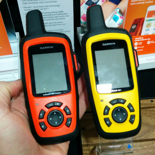
The new Garmin inReach SE+ (yellow) and Explorer+ (orange) are best described as conventional handheld GPS units with satellite text messaging.
Overnight I received this question from reader Bob B.:
Can other topo maps be downloaded onto the Garmin inReach Explorer+?
This question — and just about any other that you can imagine — has been answered previously in my previous posts about the Garmin inReach SE+ and Explorer+:
- Preview: New Garmin inReach SE+ and Explorer+
- 12 FAQ’s: inReach SE+ & Explorer+ || Incl, Will old devices be serviced?
But I sympathize for any reader looking for the answers, because there are a dizzying number of informative comments — 240 total and counting. So I have decided to aggregate map-related information into this single post, to make for easier finding.
inReach SE+ vs. Explorer+
In 2016 Garmin bought DeLorme, which released the original inReach SE and Explorer models in 2014. In 2017 Garmin released two new inReach models:
- Garmin inReach SE+ ($400)
- Garmin inReach Explorer+ ($450)
The primary difference between the devices is that the Explorer+ is pre-loaded with topographic maps while the SE+ has only a simple grid map (i.e. no features or contour lines, just its location plus any imported or created routes, waypoints, and breadcrumbs).
Deeper dive: inReach Explorer+
Pre-loaded data
When purchased in North America, the Explorer+ is preloaded with the following maps:
- Topo 24K for the US and Canada (Made by DeLorme)
- Topo 125K for Mexico (Made by DeLorme)
- World Wide BaseMap (Made by DeLorme)
These maps have not been updated since the 2017 product release, and they will not be updated by Garmin.
Downloadable data
The Earthmate has 2 GB of internal storage for additional data.
The following maps can be added to the device:
-
- OpenStreetMaps, which covers the world and offers road detail, and light topographic detail. Sometimes they include trails. These maps are just like Garmin’s Cycling maps, and receive updates.
Earthmate Hunt Editioncosts $35 per year and includes GMU boundaries, land ownership, and public land survey maps for all 50 states. It can be viewed directly on the inReach Explorer+ after being synced with the Earthmate app.Per Levi.
What’s not pre-loaded or downloadable
The Explorer+ (nor the SE+) have SD or micro-SD slots, so data that is stored in this format (e.g. Onxmaps Hunt Chip) cannot be loaded.
The devices are not compatible with Garmin Base Camp, so you cannot load the data onto the device from there. Instead, you must use the Explore portal, which was carried over from DeLorme. I would expect the second-gen Garmin inReach units to be better intergrated into Garmin’s systems.
None of the preloaded or downloadable maps offer automatic routing. This is different from Garmin City Navigator and Garmin Topo 24K maps, which will give turn-by-turn directions between two points using roads or trails.
Earthmate app
The Earthmate app is included with purchase of an inReach SE+ or Explorer+, and it can be purchased separately. In addition to the aforementioned OSM and Hunting Edition maps, additional data can be downloaded to Earthmate:
- NOAA Nautical Charts
- Aerial Imagery
- USGS 7.5-minute quads
- Canadian quads
These tiles cannot be viewed directly in the inReach devices. However, the inReach GPS can be used to identify its location on the phone screen, rather than using the phone GPS.
Functionality with and without a subscription
To use the inReach as a two-way satellite messenger, a service plan is required.
To use the inReach as a GPS, the device must be activated but does not need a valid service plan. This currently costs $25 per year.
My brother purchased the Garmin SE+ for our 95 mile Uinta Highline Trail trek in Utah last summer. We really enjoyed the functionality of being able to send messages to our families, and they enjoyed being able to track our progress throughout the week. Also, having the peace of mind that we could summon help in an emergency was an important benefit.
That said, there was one annoying issue. My brother continually had to fight with the GPS unit to sync up with his iPhone, and it routinely un-synced, which was really annoying. We are both pretty tech-savvy, so I don’t think that it was an operator issue.
Overall, the communication abilities more than outweighed the sync annoyances. If you are going to be travelling in remote areas, having the ability to get emergency help is an important consideration, and this unit provided a lot more functionality than a Spot device would.
“To use the inReach as a GPS, the device must be activated but does not need a valid service plan. This currently costs $25 per year.”
That… seems like it’s kind of crap. I believe even my older Delorme without a plan will at least give me lat & long coordinates. Do you at least get updated basemaps?
I understand both sides of this. You have to consider that the inReach SE+/Explorer+ are first and foremost a two-way text messenger. If you want just a GPS, they have those available, and there is no ongoing expense after initial purchase.
If your subscription is not valid, the loaded maps that do update (e.g. OSM, but not the DeLorme data) will update.
Andrew, thanks for all your posts on the inReach devices. I recently bought an old DeLorme SE and I plan to use it exclusively for satellite messaging. I also always carry a small Garmin Etrex 20x GPS for navigation and to geotag my photos later from the high resolution track. I always leave the Etrex on except when I’m sleeping. With lithium cells battery life is about 65h, enough for most 5 day excursions.
Garmin should really offer a next generation inReach+ with the same GPS and map download functionality and the small size of the Etrex and integrated satellite communication that can be switched on when needed.
And Garmin, please fix the four way controller on the Etrex: it is pushed around too easily when the device is in a shirt or hipbelt pocket.
It would be nice to have one device for navigation and satellite communications. This post (and the comments in the previous posts) helped me decide that the current Garmin Explorer+ is not for me. I consider the relative inability to add or update maps a deal breaker. I don’t know why they shipped this device this way, other than to make it look like a Garmin product.
For emergency two way satellite communications, I ended up purchasing a previous generation (pre-Garmin acquisition) InReach SE. This works well.
For navigation, I’ve moved from using a Garmin GPSMAP 62s to my iPhone running GaiaGPS. The Garmin worked well, but I really wasn’t using it. The interface of GaiaGPS is FAR superior. Of course, I still carry, and know how to use, a map and compass.
Does anybody know if Garmin is working on a (soon to be released) gen 2 explorer+?
It seems like a very nice device, but I am hoping for something with a usable GPS with Garmin maps support and hopefully a bigger internal memory or (micro)SD support.
You can also subscribe here for a sattelite data plan for the explorer+ in stead of via Garmin:
https://www.protegear.de/english/
The plans look better, but unfortunately you still have to activate lets say a one day or week data package before you leave for the outdoors. So it won’t work if you try to activate SOS without an active plan. But it is nicer for the occasional hiker.
Haven’t heard anything, and didn’t see anything new at Outdoor Retailer in January (where Garmin probably would have been showcasing a new device if they had one). Maybe there is something new at the OR in July, but that means a holiday arrive at best.
Any idea what the options are for loading a South American topo into the InReach Explorer? Specifically – Ancash Region of Peru….
I just noticed this on the Garmin site:
” Earthmate Outdoor and Hunt Edition are no longer available for purchase.”
Guess it’s time to update your article.
Any insight as to why?
No insights, sorry.
So is it my understanding that you cannot download map onto the device SE+. Correct?
I followed all the tutorials I could find and when I go to the garmin webpage with the garmin connected I do not have the option “Get More Maps”. inReach sync and firmware updated
Am I doing something wrong?
You cannot download topo maps to the SE+ device, only the Explorer+.
But you can download maps to your earthmate app.
Andrew, can Earthmate use maps NOT from Garmin? (I have a Mini, so quite dependent on the app for visuals.) I’m going to Chile, and it seems that the map already in the app is very lacking in detail. For download, Garmin only has satellite imagery (BirdsEye) for that area. I much prefer to have a topographic map as well. Actually, so far I haven’t found any good sources, but there must be some.
The image data listed in this post is the extent of data that can be viewed on an inReach or in Earthmate.
If you want other imagery, consider the GaiaGPS or CalTopo app.
I have a big problem with my explorer+. I’ve purchased the device from amazon 4 weeks ago. I am living in Istanbul and tried everything to get a local map from inreach sync, but couldn’t achieve anything.
I have an active plan, the device is activated, I am able to send waypoints and contacts from my garmin account page and earthmate app. So the usb-cable is working but the only maps that I have on my device are the preloaded ones. I’ve also tried a win7 and 10 machines, and my macbook. No way. Also it is not related to Turkey map, I couldn’t download any other map as well So, any experience like this?
Hey Andrew, do you have any insight / theories on when a new series or an update might happen – particularly around loadable maps, Base Camp and 24k topos. I guess it can be achieved without introducing a card slot so need not be a hardware upgrade.
No, I do not.
Looks like they came out with the new device today. GPSMAP 66i. MSRP of 899 CAD at MEC. I want one but at 900 bucks it better be one heck of a good unit. Personally I felt 600 plus the cost of the service plan was more then enough.
Struggling to justify that expense.
$300 for inReach Mini gives you the same functionality when you pair it with your phone (which you probably carry with you already). And $30 per year gets you a GaiaGPS subscription, which is more powerful and user-friendly than what Garmin includes in a handheld GPS unit.
Awesome, I’ll have to check that out. Thanks for the help Andrew
Not the advance I was looking for. I ended up going with precisely the combo Andrew has outlined – Mini + Gaia premium. Earthmate is pretty rubbish but with my configuration it’s not really an issue. 66i brings more features but also a shorter battery life, so will be OK for day trippers but could have done with replaceable AA batteries for longer tours.
How do you guys find the battery life on your phone? Most likely need to carry a battery pack as well for a couple recharges?
Aux battery for sure. But my phone is my map, my camera, my book, and my music. The other thing that helps in the cold is a hand warmer stuck to the back.
Awesome thanks Mark. Do you have a battery pack you recommend? I have one from Costco that’s half decently light but only get 2.5 charges out of it.
I have a Cygnett but I’m in Australia so your availability is likely to vary. Available in many sizes/weights.
Thinking of the mini for a hiking trip in Utah and then around my area, since I usually hike solo. I’m confused by some posts about use as GPS without a service plan. Do you need the $25 activation in order to get any of the personal plans? Not sure I want to use this as a GPS, but I do want to be able to use it for messages. Thanks.
To use the Mini as a messenger, you must activate it ($25) and have a monthly or annual plan.
It can be used a GPS, but personally I prefer to use my phone with an app like Gaia or CalTopo.
Hi Andrew,
I’m lost here and I hope you can help. Owner of a Inreach Explorer+ I can’t find the way to see areal maps on my device and Earthmate. I have the sattelite imagery in my MAPS on my desktop
Earthmate maps management only allow Topographic or open map downloads.
Any insight?
Honestly, my suggestion is to sell your Explorer+ and buy a Mini, and then use your smartphone as a GPS using an app like Gaia. More reading, https://andrewskurka.com/navigation-system-equipment-watch-compass-altimeter-gps/
If you want to stick with the Explorer+ as your GPS…
Here are preloaded maps, https://support.garmin.com/en-US/?faq=oY5Byabd45ADYui9hV2dbA
You can download some additional maps, https://support.garmin.com/en-US/?faq=WEcKUBmQyk4t2c3c2eD5WA
And here’s how to manage the map displays, https://support.garmin.com/en-US/?faq=Ma7l48GTtR3nnieOwcKPl5
I have the Garmin InReach SE+ and have done nothing to it at all, is there anyway to get maps onto the GPS? Do you download them somewhere and then put them on the inReach? Or is the Explorer the only one that can have topographic maps and contours?? If that is the case it seems like the SE+ is a waste of money. Its one thing to plot points but with no clarity of contour what is the point?
Use your SE for messaging, and get Gaia GPS for GPS nav. More reading, https://andrewskurka.com/navigation-system-equipment-watch-compass-altimeter-gps/
Is it possible to download road maps onto the Garmin Inreach Explorer+? I’d like to take a tracker with me on motorcycle trips but would also like it to serve as a backup GPS.
Hi Andrew, I am using my SE+ for messaging, and Gaia GPS for navigation as you have suggested. It works well! Now to something else into the mix, I have a Garmin Fenix 5x watch that has decent maps but more importantly I like all the detail it tracks when I go for a hike (heart rate, pace etc.). Is there any way to integrate these things?? ie Gaia and Garmin Connect (Fenix) data? Currently what I do is track my route via Gaia and Fenix, but then I always have two sets of data.
Also…why the heck SO MANY Garmin sites and software!!!! Wouldn’t it be wonderful to have one piece of software that links all your devices?? I live in Calgary, I should head to their office in Cochrane and ask them! LOL
I don’t know of anyway to blend Gaia and Garmin data during the trip or even afterwards.
You don’t need duplicate tracks, so I would turn one of them off. Personally, I’d turn off Gaia, because I get more value from having that data on my wrist than in my pocket. Also, my Suunto Ambit3 Peak beats the heck out of my phone for battery efficiency, so I can run my Ambit for several days without recharging whereas my phone would probably only make it a day if left on continuously (even if it’s in airplane and battery-saving modes).
Hey Andrew,
I can’t find a way to activate the device for $25 only. I bought it for the possibility to eventually use the subscription feature but only need the gps feature right now. I would like to load routes on it but I can’t get the Earthmate app to work it seems without paying for a subscription.
Thanks for any advice!
The inReach (and all other Sat messengers too) are vastly inferior navigation tools relative to dedicated GPS apps like Gaia and CalTopo. Use your inReach for sat messaging only, and don’t activate until you need that functionality.