
Cascading waterfalls below the Blackfoot Glacier, the largest and most active glacier along the route.
When I first saw Dave’s sketch of a high route through his beloved Glacier National Park, its appeal was not immediately obvious to me. Unlike more familiar lines (Roper’s, Winds, Kings Canyon), which generally hug major watershed divides by hopping between lightly traveled basins via off-trail passes, Dave’s line appeared to be a contrived ribbon of extended sidehills and improbable ridgewalks that was in a constant fight to avoid deflating drops into low valleys (and the thick brush that awaits there). Sure, it could be done, but would the effort-to-reward ratio be justifiable?

Upper Kintla Lake and Long Knife Peak, one of two trail routes to Brown Pass, where the route really begins. While Glacier is technically part of the Rockies, its lush west side looks much more like the Pacific Northwest.
Other information about the route was scarce. In Climber’s Guide to Glacier National Park, J. Gordon Edwards inserts vague descriptions of a Continental Divide Route throughout his definitive text. Richard Smith pieced it together over fifteen years, but is intentionally mum on details. Jeff Rome did the same last summer, but again provided little actionable advice. Of course, route beta for smaller segments is scattered throughout the internet, but finding it all (and confirming the accuracy) may take more time than actually doing the route.

The high traverse between Thunderbird Mountain and The Guardhouse is one of two major crux sections. The conventional route is to follow the sloping ledge that extends from our current location to the pass at the opposite side of the valley. Dave and I instead dropped to the valley floor.
Despite my reservations, when Dave invited me in February to join him on an attempt this summer, I cleared my calendar. When I’ve had the opportunity to learn from someone who is intimately knowledgeable of something — whether it be Glacier, ranching, or Quickbooks — I’ve rarely been disappointed.

Behind Dave notice the Ursack, which is an approved food storage method in Glacier. They are SO much better (at least in terms of user-friendliness) than a hard-sided canister.
True, it would be a blind date, since we’d never met, but I thought it’d be okay so long as our online personalities were at least partly reality-based. (Update: They are. As you’d expect, Dave is more abstract and I’m more exact. But our walking speeds, skill sets, and personalities are similar and/or complementary.) Plus, this route is best done with a partner, as a safety measure and emotional check.
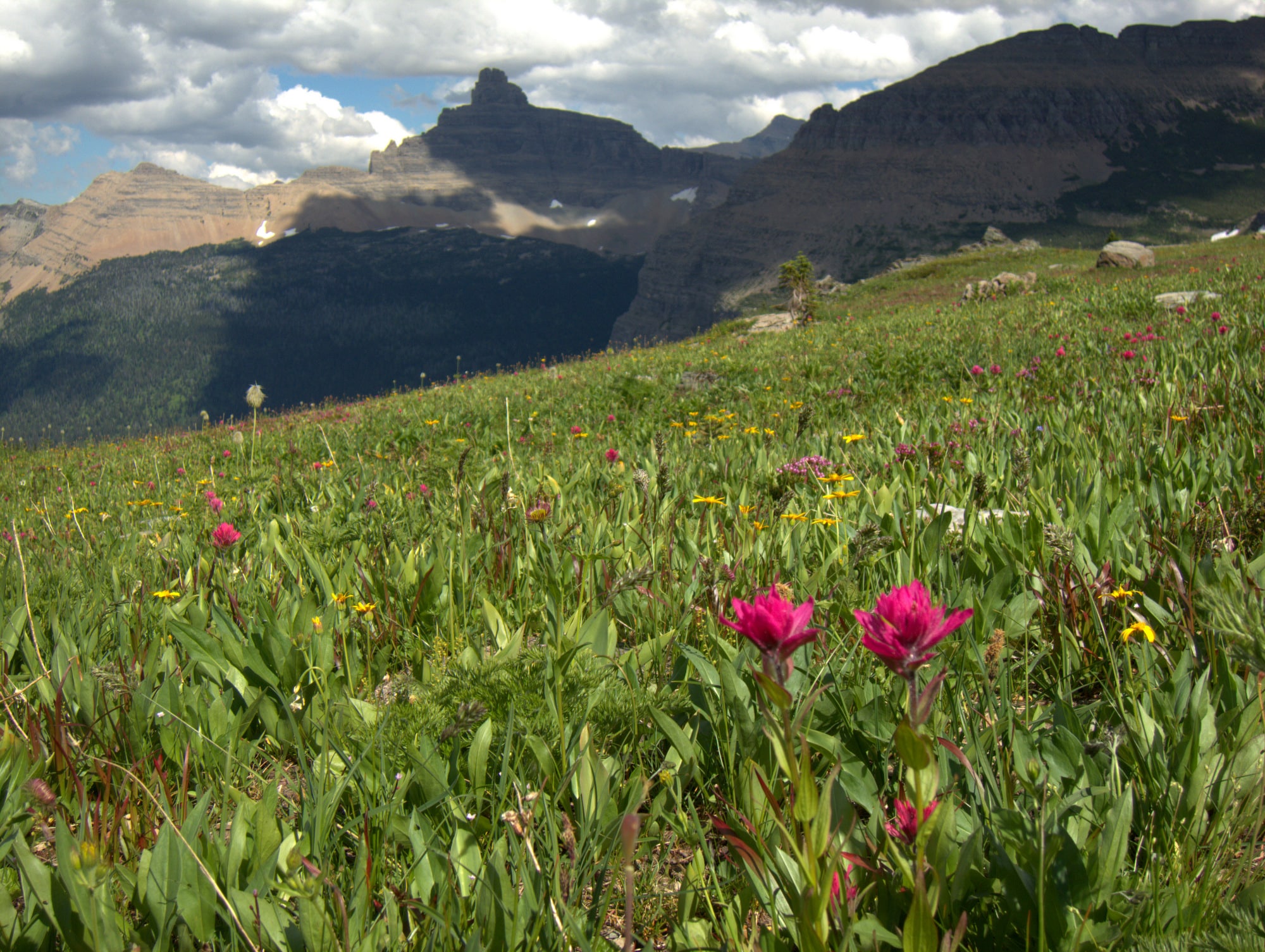
July is prime time for alpine wildflowers in Glacier. Indian Paintbrush and Split Mountain.
We planned a 6-day/5-night itinerary, starting at Kintla Lake and exiting at Marias Pass. This timeline was based on Dave’s gut estimate, but when I started digging more deeply into the route the week beforehand, its 40k+ vertical feet of climbing sounded more like a 7-day route to me — assuming that we were not delayed by bad weather, mistaken navigation, planning oversights, or beaten bodies. In hindsight, an 8- or 9-day itinerary would have given us a more practical margin for error.

Mountain goats live in impossibly steep terrain. When you start to think highly of your scrambling and mountaineering skills, watch goats go about their daily business.
On the first day we hiked efficiently to just beyond Brown Pass, and were set up perfectly to start the traverse between Thunderbird Mountain and The Guardhouse in the morning. That section was extremely slow — we made it only 12 miles in about 12 hours. The complicated travel is highlighted in Dave’s video:
We reached the Highline Trail on the afternoon of Day 3, and both promptly fell apart — Dave from an inflamed Achilles, and me from sickly feet.
In the morning we bailed at the halfway point, Going-to-the-Sun Road. I returned later in the day solo, while Dave remained home to nurse his ankle. From Logan, I made it to Triple Divide Peak — at the southern end of the Norris Traverse — before exiting at St. Mary’s and rendezvousing with my car, which we’d shuttled during our down time. That left unfinished 20-30 miles of the route, but no doubt I’ll be back next summer.

Almost-a-Dog Pass, looking south over the Red Eagle Bench and towards the Norris Traverse.
As it turns out, the Glacier Divide Route is indeed different than other high routes. The vertical relief is more dramatic. There are fewer viable alternate routes. Most bailout options are Alaska-like: often worse than plodding on. Airy scrambles are more commonplace. Of course, there are bears and tighter backcountry regulations.

The new Sierra Designs High Route Tent, perched on the Continental Divide just below Triple Divide Pass. At-large camping is limited in Glacier and requires a special permit.
But the biggest difference is the underlying geology. Glacier is more like an inverted Grand Canyon, and the secret of off-trail travel is finding walkable ledges (ideally covered in goat tracks) and non-technical seams between them. Topographic maps and Landsat imagery offer suggestions, but on-the-ground reconnaissance is the ultimate validator.

From just below the summit of Norris Mountain, with Razoredge across the valley. I nearly ran out of daylight here, but thankfully made it to a great camp just before I had to turn on my light.
Looks awesome! A good reason to get back up in Glacier.
That looks like an awesome trip. Probably a little too much exposure for my comfort level in places, though I have ended up in a few spots like that myself. I follow both your and Dave C, blogs and both are well done. Nice video too, I assume that was shot with a Gopro.
David has a GREAT blog as well. Too bad about the injuries! Awesome trip though.
Hi, I coincidentally stumbled across your post via a search. My wife and I crossed paths with you North of Mt Norris. We we’re Going East to West. Really great trip and cool to read you’re account. Here are some photos of our trip if you’re interested.
https://www.dropbox.com/sh/cf7mfk3s870javf/AADaKJTsTk62GRbfPIgvW0Ila?dl=0
Wondering if I would hear from you guys again. Nice route, glad to see someone else out there enjoying it.
Great photos, BTW. What kind of camera were you carrying?
Yeah Pretty random. I carry a Sony A6000. It’s a small mirrorless camera with interchangeable lenses. Great for throwing in a pack.
We’re hitting Glacier in August. What are your thoughts on a tarp+bivy (Borah Snowyside) over a self-supporting tent (REI Quarterdome 2)?
For the Glacier Divide Route I would recommend a full-sided shelter like the High Route Tent or a mid, plus perhaps some bug protection depending on the season.
For an all-trail route personally I would use a tarp + bivy, to save some weight. I would also consider a hammock, so that I don’t have to sleep on those hard designated campsites. But not all camps have suitable hammock hanging locations.
When in July did you attempt this route?
Mid-July after a light winter but a cold spring. The Thunderbird Traverse is best done later in the season, so that the snow plugs are gone and so that the goats have benched out more of a trail. But the southern crux of the route, the Norris Traverse, is best done a bit earlier, so that you can grab some water from lingering snowfields.
A late comment perhaps, but My Own Frontier (Joey Coconato) has a great video on a similar route. Parts of it makes me eyes wet.
Awesome trip report! You have a way of describing the challenges of ridge hiking in Glacier that hits the nail on the head more than other blogs I have seen. I am doing the traverse in two weekends from Triple Divide to Almost a Dog Pass and then down to Gunsight Lake and out. I realize you did it earlier in the season but do you have any thoughts on whether an ice axe or crampons would be essential for any of that?
They were marginally necessary when we did it. You’d have to look at snow data to determine how mid-July in 2016 compares to mid-August in 2019.