Thanks to a delayed arrival of winter, in late-October of last year I finished piecing together the Pfiffner Traverse, a 77-mile high route through Colorado’s Front Range between Milner and Berthoud Passes. But I felt it important to get on the route again this year as a thru-hiker and as soon as conditions permitted, to gain a more holistic perspective, to determine how runoff and lingering snow affects the route, and to give the Pfiffner Traverse Guide a final edit.
For several reasons I recommend thru-hiking the Pfiffner Traverse southbound, from Milner to Berthoud. My yo-yo started at Berthoud, which gave me a chance to check conditions and scout several alternates before hitting the turnaround and giving the second leg an honest go. I started with 9 days of food (minus a dinner) and finished in 8.5, for an average of 20 miles and 7,000 vertical feet of climbing per day.
From nearly 1,000 images, I’ve selected twelve and organized them geographically from north to south:
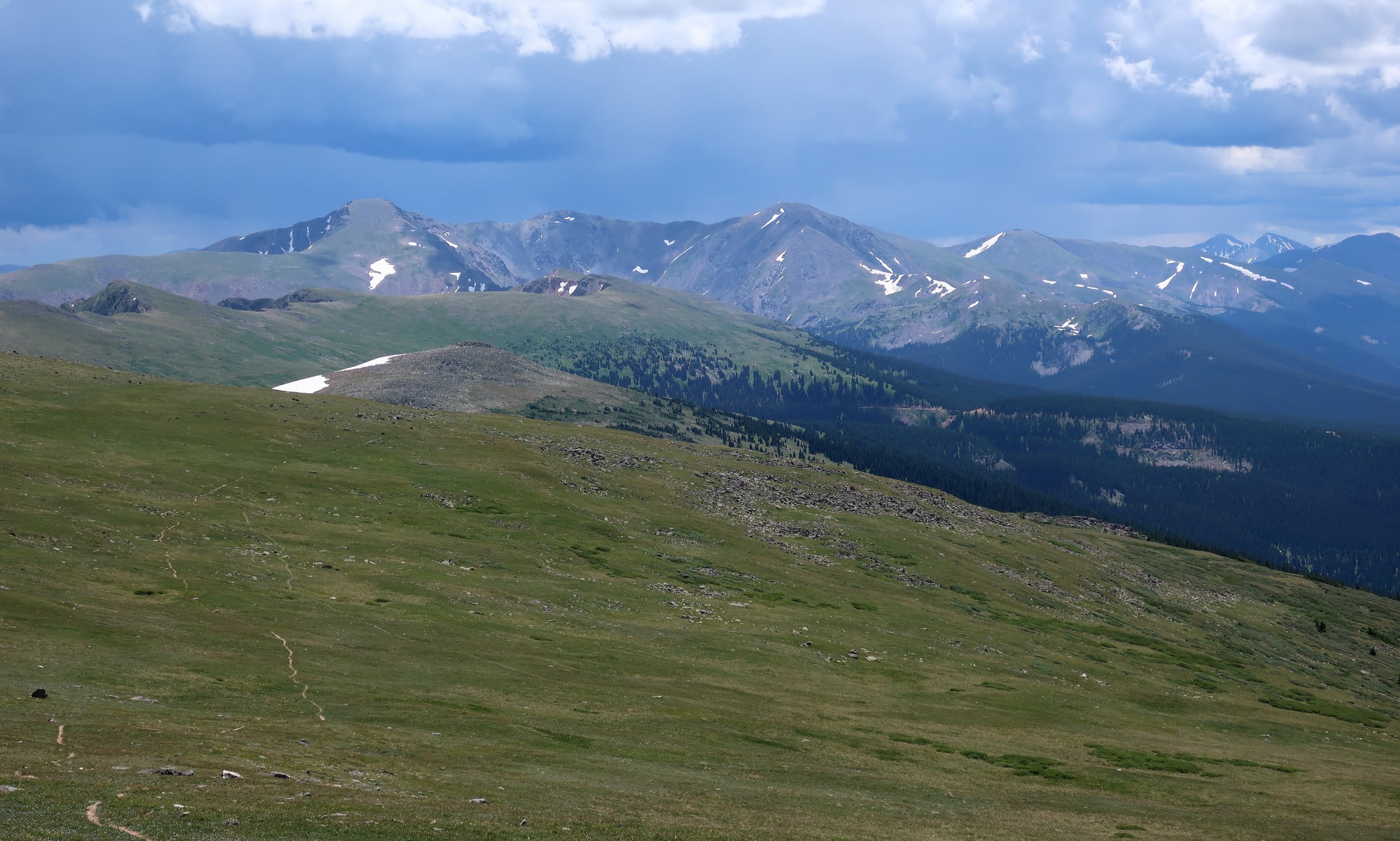
From Milner Pass, where Trail Ridge Road crosses the Continental Divide in Rocky Mountain National Park, the Pfiffner Traverse climbs five miles to the summit of Mt. Ida (elev 12,865). The trail is mellow, but it thrusts you immediately into Sound of Music-worthy terrain.

The Mt. Ida Trail, looking north towards Milner Pass, Specimen Ridge, and the Mummy Range.
Assuming a normal winter, July is my favorite month for high country travel in Colorado. Seasonal vegetation has greened up and wildflowers are blooming, but lingering snow still laces the high peaks and leeward slopes. The bug pressure is relatively light and easily managed.

A lush wildflower-filled meadow in upper East Inlet.
If I see as many elk and deer in November as I did on this trip, I will most certainly fill my chest freezer. I saw big herds (up to 40 head) at Sprague Pass, on the south side of Ptarmigan Peak, in Paradise Creek, and at a honey hole on USFS lands that I won’t mention.

A trophy bull near Hallet Creek in Rocky Mountain National Park. So long as he stays within park boundaries, he’s got a good life.
One perk of off-trail exploration is the “discovery” of unknown features and places, such as this 30-foot waterfall that gushes with spring runoff. To break through the cliff band that wraps the valley, an elk trail must be followed.

An unnamed waterfall on an undisclosed creek known only by elk and Pfiffner Traverse hikers.
The Pfiffner Traverse consists of a recommended Primary Route as well as easier and harder alternates that can be followed in the event of inclement weather or extra energy.

Thunderbolt Creek, as seen from the Ooh La La Extra Credit route, north of Buchanan Creek.
An unnamed alpine lake in upper Thunderbolt Creek, which can be appropriately referred to as Paiute Lake since it sits immediately below Paiute Peak (elev 13,088).

Paiute Lake in upper Thunderbolt Creek
The most technical and hazardous section of the Pfiffner Traverse is the Northeast Gully, which is the least difficult route out of Lone Eagle Cirque and into upper Arapaho Creek. When it melts out, usually by August, it’s supposedly Class 2 scree and talus. If 40-degree snow slopes aren’t your thing, there’s an all-trail route around. The route never exceeds Class 2+/3- in difficulty.

In mid-July after a very wet spring, the Northeast Gully was still loaded with snow. An ice axe was mandatory, and crampons are highly recommended.
My favorite part of the route is its middle, from North Inlet to Columbine Lake. Arapaho Creek is near the southern end of this segment, and has perhaps the biggest scenery of all.

Upper Arapaho Creek, looking north over Caribou Lake towards the Achonee-Hopi ridge, Tribal Lakes basin, Mt. George, and Apache Peak.
Of the eight nights, I cowboy camped (i.e. slept under the stars) for five. For more exposed camps and inclement weather, I was happy to have the Sierra Designs High Route 1FL, which weighs just 22 oz for the fly.

The Sierra Designs High Route 1FL, pitched near Heart Lake on the last night, with James Peak looming 2,000 vertical feet above.
As I ate through my food bag and as the end drew closer, I took on longer and harder days. My daily mileage varied between 13 and 25 miles, but the amount of climbing was more consistent: between 6,000 and 8,000 vertical feet per day.

On average, the Pfiffner Traverse climbs or descends 800 vertical feet per mile. One day, I climbed 6,000 vertical feet in just 13 miles, an average of 925 vertical feet per mile.
Forward progress on Colorado summer afternoons is often curtailed by monsoonal thunderstorms. The more reliable strategy is to get up early, be diligent all morning, lay low in the afternoon, and squeeze in some extra miles in the evening if conditions permit.
Ominous clouds hang over James Peak and four other 13’ers (Parry, Bancroft, Eva, and Flora) that stand between Rollins Pass and Berthoud Pass. Grays and Torreys, two 14’ers, are visible on the far-right skyline.
During my first summer in Colorado in 2003, I spent nearly every single weekend in the Front Range. But thereafter I lost the connection, obsessing about more faraway places like Alaska or the High Sierra. The Pfiffner Traverse is completely worthy as a backcountry experience, but it’s also been a personally gratifying project to reconnect with my backyard.

My sole selfie in 9 days, looking north from Mt. Bancroft towards Rollins Pass and the southern Indian Peaks.
Looks like an amazing route. I’ll consider doing it as well, since it is right in my backyard too!
What an amazing looking route and pictures.
One question since you have done the Sierra High Route, the Wind River Route, and the Phiffner Traverse, which has the least class 3 passes and/or technical sections? If you had to rank them in order of difficulty, how would you rank them?
The Pfiffner Traverse has more vertical per mile than any other high route.
The Wind River High Route spends the most time above treeline, has the nastiest weather, and has the most off-trail travel as a percentage of its overall length (tied with Kings Canyon High Basin Route).
The Sierra High Route is the longest.
The Kings Canyon High Basin Route spends as much time off-trail as the Wind River High Route.
In the contiguous United States, what has been your favorite route you have traversed? (I know – that’s hardly a fair question.) I have a month off this summer, and I am currently brainstorming a creative route to do. I’ve done the Sierra High Route and I loved every step of it; I wouldn’t mind doing it again. But before making a final decision on tackling the SHR again, it is of course worthy to research other phenomenal routes. Any suggestions of routes worthy of researching??? I have a month off so if I did do the SHR, I may yo-yo and leave plenty of time for peak scrambling and tangential explorations, which I’m sure would be a rich experience.
Thanks,
Brian Peterson
It’s not a fair question.
There is so much else to do out there, Why do the SHR again? If you want to stay in the High Sierra, at least check out the Kings Canyon High Basin Route and/or Southern Sierra High Route. If you want to come to Colorado, then definitely look at the Pfiffner. If you can get a few days in Washington, too, that Ptarmigan Traverse looks excellent, or go a little further east and do the Glacier Divide Route.
The SHR is worth doing a second time. But only after you’ve done these others.
What are the several reasons for which you prefer to hike Pfiffner southbound? How hard would it be to do this without a permit and instead camping at the borders of the IPW and RMNP? 30 miles to get through RMNP right? It sounds like type 2 fun but considering it by going light and stoveless.
Two main reasons to go southbound:
1. Save the James Peak Skyline (which has five 13’ers) for last, when you’re better acclimated; the north end is lower, and has alternates that are lower still.
2. More easily stick to your itinerary in Rocky, which will be inflexible because of their campsite policy. If you go northbound, there’s a higher chance that you will be off by a half- or full-day by the time you reach the boundary.
Completing the northernmost 30 miles in one push is a possibility, but for only a few. Those 30 miles have 10,500 vertical feet of gain (when going northbound), which is 2x to 3x more than what most people can do in a day. For context, my sustainable upper limit is about 7k gain per day. Not sure that 10k becomes easy simply by going light and not carrying a stove.
If you’re strong enough to push through most of Rocky in a day, you might try to get a walk-up permit, or start calling several days in advance to see if there are some openings. They get cancellations frequently. And it sounds like you could make it work if you get one campsite between Mi 10 and Mi 20, or approximately between Onahu XC and upper East Inlet.
Andrew, planning on doing this route SoBo with your trail guide in hand the second week in Sept ’19 (have all my permits in hand). Needless to say I am super excited to traverse the Rockies. With this years snowfall how should I prepare? Since you have an intimate knowledge of this area will the route be melted out or should I be prepared with micro spikes? Ice ax? Anything else I may need to adjust? Your thoughts would be greatly appreciated.
Thank you
Even after a wet winter, I don’t think you’ll have a problem with snow during your trip.
https://andrewskurka.com/pfiffner-traverse-ice-axe-crampons/
Thank you for the quick response and taking the time to answer my question. I know you’re really busy this summer. I’ll prepare to have my shoes shredded with all the talus and scree I’ll be walking on.