The $400 and $450 retail prices on the new Garmin inReach SE+ and Garmin inReach Explorer+ probably causes many prospective customers to balk. Like the second-generation inReach units, the inReach+ models can send and receive text messages and emergency signals even if outside of cellular range.
But the inReach+ units are more than just that. They are better described as handheld GPS units with inReach technology. The SE+ is a fairly basic unit, while the Explorer+ has the features you’d expect in a mid-tier GPS-only device, like full-color topographic maps and a digital compass (so that it knows its bearing even if it’s not moving).
Is this all worth $450 or $500 to you? I can’t answer that without knowing more about your intended use and budget. But I can help you learn more about exactly what inReach+ is and does. Here’s a deeper dive into a few of the details:
1. Topo North America (NA)
The Explorer+ is pre-loaded with DeLorme Topo North America (or Topo NA), a proprietary topographic mapping layer. What does it look like? Here are some screenshots:

Screenshots of Topo NA
Topo NA is based on the gold standard USGS 7.5-minute quadrangles. I don’t find it to be as aesthetically pleasing, but it’s functional and it’s more up to date. Here is a side-by-side comparison:

Delorme’s proprietary topo map layer (left) versus the USGS quads as shown in Gaia GPS
The Topo NA data has been finessed some for the Explorer+. Per Garmin: “We’ve improved the contour drawing process to adjust the density on the fly and make the maps more readable in the mountains. We wanted climbers to be able to see the individual contours and their labels rather than just seeing brown when the elevation change is dramatic and the contours draw so closely you can’t tell them apart.”
Topographic maps are NOT pre-loaded on the SE+, and maps cannot be user-loaded. The SE+ only has a primitive grid map with lat/long. However, you can pair the SE+ to a smartphone with the Earthmate app, which can display Topo NA, USGS quads, and aerial imagery so long as it’s downloaded beforehand (or has cell service).
2. Quick type
The “virtual keyboard” on the second-generation inReach devices was carried over to the inReach+. Typing messages on it was a slow and tedious process. However, it allowed you to send messages without carrying a smartphone, and it’s arguably more user-friendly in crappy weather (i.e. rain and cold, when smartphone touchscreens are difficult to use).
Garmin improved the keyboard for the inReach SE+ and Explorer+ by adding a quick-type feature. It will suggest words in its dictionary and words that the user has typed before. Screenshots:

Screenshot of the new quick type feature
3. Service test tool
More than a few users have carried their inReach (or SPOT or satellite phone) into the field, only to realize that it was not functioning properly, sometimes a few days later when a helicopter flew overhead looking for them.
A service test tool should have been on the second-generation units, but was not. The SE+ and Explorer+ have it. Screenshots:

Service test
4. Weather forecasts
Using the excellent WX2InReach service, it was possible to have location-specific weather updates sent to a second-generation inReach, either regularly or on-demand.
The inReach+ units have a built-in weather forecast tool for land and marine uses. Details, per Garmin: “The weather for our land-based forecasts comes from Dark Sky, maker of the popular Dark Sky app and the forecast.io API, the same used by WX2InReach. Weather forecasts for the majority of the world will be the same for both WX2inReach and Garmin inReach+, and our tool will offer hourly granularity and seven day forecasts and an easier to read interface.
“The forecast is specific to your location, so you will definitely see different forecasts over a 5 mile range. But my research has led me to believe that it does not take into account elevations in a way that a high summit forecast would. I have tested this out by comparing the valley and summit forecasts received by inReach with those given by the Mt Washington observatory. What I found was that the inReach forecast was more of an average for the area that I used as my location coordinates.”
[Last updated February 8, 2016. In the original post I was given an incorrect source for Garmin’s weather data.]
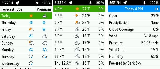
Screenshots of the inReach+ weather forecast tool
More questions about the inReach+?
If you have not done so already, read my other posts about the inReach+. Also, feel free to leave a comment here. I have a reliable contact on the inReach team if the question has not been asked and I don’t know the answer.
Disclosure. I strive to offer field-tested and trustworthy information, insights, and advice. I have no financial affiliations with or interests in any brands or products, and I do not publish sponsored content
This website is supported by affiliate marketing, whereby for referral traffic I receive a small commission from select vendors like Amazon or REI, at no cost to the reader. As an Amazon Associate I earn from qualifying purchases.
I have the Inreach Explorer but am considering the InReach Explorer+ just because of the test feature and it looks like better mapping. Probably like others the only way I knew if the InReach Explorer was working was to send a text to someone and then wait for a reply. And sometimes as in a canyon–you didn’t know whether it would be working or not!
My question-Does the new test feature give instant(or fairly instant) feedback?
Thanks
Ron
I would imagine that it’s similar to the confirmation you get when sending a message. No reason there should be any longer delay in the system than the time for electrons to travel between the device, satellite, and control center.
What is the difference between the service test and a test message that can be sent out on the Explorer?
And I prefer the WX2inreach forecasts over the Delorme/Garmin ones.
And if you have wx now as one of your 3 preset messages, it won’t cost you a message to send, only a message to receive the forecast.
The “old” test system is explained here, https://explore.delorme.com/setup/test. Since this is a DeLorme URL, which might go away, I’ve included a screenshot of the directions below. It’s a more involved process than an on-device one-screen test tool.
I think it’s premature to say how the built-in forecast service compares to the WX2inReach service. Even if WX2inReach is better, at least Garmin has offered a tool for users who are not in the know.
You might be delighted to re-read the section about the built-in weather forecast, which reflects some corrections that Garmin sent me. They are using the same data as WX2InReach.
Does the new generation (Inreach+) still have the ability to get the WX2InReach forecasts?
If those can be more location-specific than the more general forecast provided by the built-in functionality, it would be nice to have both.
Yes, that service remains in tact with the inReach+ devices.
Good news. My original info from Garmin on the weather data was incorrect. They are actually using the same API as WX2InReach uses.
Here’s a Garmin quick-start video tutorial on how to set up and use inReach Explorer+
https://www.youtube.com/watch?v=_k5JOND4l-k
Hope you find this useful.
Nice work and thanks for pulling this information together! Very helpful. Do you know / can you ask, if you suspend while using the freedom service, will you loose any functionality in your Earthmate App capabilities?
It seems to me, I will have a two device solution. I ride ADV motorcycles and get into backcountry time to time, and am looking to purchase my first gps and SOS device. I’ve been using the Advenza map app with USGS quad pdfs on my iPhone (all free except phone), but it doesn’t feature the navigation for downloaded gpx tracks. I can upload them but then I have to scroll to keep my position on the screen, instead of the app auto scrolling along the route. Not a good solution on motorcycle.
I’m assuming the Earthmate app does autoscrolling / map centering while actively navigating a route on both the inReach device, and the app on the iPhone, do you have any info on that capability?
I’m hoping the iPhone w/ app will allow me a better view at higher speeds. The inReach device will give me the SOS backup and text capabilities in the boonies. Thanks again
Thanks.
The Earthmate app works irrespective of your subscription status.
I’ve never used the Earthmate for such an extended period of time that it had the chance to auto-scroll. If this is a common feature of GPS units or GPS apps, then I would say it might have it. But if this feature is normally only something you see in in Google or Apple maps, or in a car GPS, then I’m unconvinced it will have it.
I was wondering if there is a battery penalty for the Explorer+ with the additional functions, so I contacted Garmin. Here is their response:
“The Explorer+ battery life is very similar to that of the SE+. The mapping uses the additional storage space provided on the unit, but this will only have an effect on battery life if it results in you leaving the screen on longer in order to follow the map (so the additional battery consumption is just from extra screen use). The compass and altimeter will each also have a minimal/negligible effect on battery life. If I had to make an educated guess, I’d say perhaps an hour difference for every 100 hours of use would be a good estimate.”
Do you run Earthmate concurrently with GaiaGPS on your phone, or only access Earthmate if you want to compose a message?
As a sidenote, if I am in USFS territory my preferred map is the USFS topo, which was just recently updated in 2016, and in my view is easier to read than the USGS. It is available on GaiaGPS Pro and through Caltopo at home.
I would second the USFS 2016 map. I find myself looking at it increasing more often. Glad I’m not the only one.
Garmin seems to have found a way to let the older devices do an on-device test now. You can send a message to “[email protected]” and you get a reply back. You get 5 tests a month as part of your subscription. That’s a nice upgrade for users of the older devices.
I’m new to all of this and am considering both my first satellite communication device and ABC watch. Given the capabilities of the Explorer+ would it be fair to assume it could do both jobs? If I exclude the watch then the price of this seems much more reasonable.
ABC watch? Do you mean GPS watch?
The Explorer+ does everything that an ABC watch does. It will tell you your altitude and direction of travel (even when not moving), and it will give you more accurate weather forecasts (read #4 above for details). Of course, it also has a clock.
The only advantage to a watch is accessibility — it’s right there, on your wrist. Even if you carry your inReach close, it probably won’t be as close as your wrist.
The inReach can also do most things that a GPS watch like the Suunto Ambit3 Peak can do. A GPS watch has some additional perks, though, like measuring lap distances and net vertical gain and loss. The screen display is also customizable. Finally, a GPS watch can take your endurance training and racing to the next level, but you’re never going to run an ultra with an inReach in your pocket.
Thank you for your response Andrew. I would be 100% in if a firmware update enabled the ability to track my net vertical gain and loss. In the meanwhile the math on this would be easy enough to do and really wouldn’t effect my decision to buy it. I’m planning my first thru-hike which will be a NOBO on the JMT. This will allow my wife to follow along from the comfort of our couch and will score me a ton of points with each of my text updates to her. Well, I have my new Ultimate hiker’s gear guide, which just arrived, to read so I’ll go for now.
Long time user of original inReach SE here. A few observations:
– Test messages using the “old way” are trivial if you keep the test address in your contacts list.
– Word prediction was always there, but usually quite useless. Has it improved?
– On a recent trip, I compared the Garmin non-premium forecast to the standard WX2InReach forecast at the same location. They might use the same API, but the WX2InReach forecast was *far* more useful. Plus WX2InReach has a bunch of other useful features. Since I’m too cheap to spring for the Premium forecast, I’ll stick with WX2InReach for now.
– I don’t see much reason to upgrade from inReach SE to inReach SE+. Am I missing something?
Is it possible to use the inReach as a bluetooth GPS for Gaia GPS so that I could turn off my phones GPS to reduce battery consumption? I would think the inReach would have a better GPS anyway. This can be done with the Bad Elf GPS receiver, but those don’t have anything like the features of the inReach.
According to Gaia…https://help.gaiagps.com/hc/en-us/articles/115003525387-Using-External-GPS-Devices-with-Gaia-Dual-XGPS-Bad-Elf-etc-
Honestly I am kind of surprised by this. But I am suspicious of how much battery it would save since you have to run bluetooth. I would expect that to burn more power than the GPS because it is transmitting and receiving. Also, it requires running the “companion app”. In my experience the GPS doesn’t actually use that much power, especially compared to the screen, which will always be by far the biggest power suck on the phone. And the GPS may be on anyway. http://alienmantech.com/blog/android-disable-gps-save-battery-power/
Is there anyway to sync your .tpo files (in this case the hayduke route as it appears in your mapset) to my inreach? I used gpsbabel to convert the file to .gpx and uploaded it as tracks, but it just showed up as about 30 random sections mostly under two miles. I’m totally new to this so maybe I’m just missing something obvious?
I don’t know how to convert it, but I know that it’s not easy.
The HDT product needs to be migrated to CalTopo, but it’s a huge lift and I’ve not carved out the time to do it.