Direct Routes around Hofsjokull
Not long after I posted the description of my traverse route I was independently contacted by two Frenchman, , Olivier “Rando léger” and David Abadie, who informed me that it was indeed possible to get around Hofsjokul, on both its north and south sides. I have posted their contact info, excepts of our email exchanges, and some links on a separate page.
Olivier “Rando léger”
Email: [email protected]
Trip Report with map and photos (in French): www.randonner-leger.org
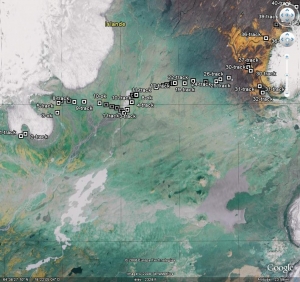
KMZ/Google Earth file of route

I’m from France and it was my second trip in Iceland, the first time (8 years ago) I went from north (Myvatn) to south (skogar) following the tracks so this time I wanted to go off track, cross country.
I did a few different choices than you: for example I crossed the Bruarjokull (it took me 11 hours and it was ok), and I managed to go from Nyidalur to Hveravellir in two days by going around Hofsjokull on its northern side. Like you, the warden of Nyidalur told me that I would be unable to reach the hut Ingolfsskali in the north of Hofsjokull and that the old track going along the west side of the Hofsjokull is very dangerous and nobody uses it anymore. But I decided to go and see, so I went cross country to Ingolfsskali by a very interesting route cross country in one day (14h) and the second day, I crossed many many rivers, but they were ok, even the famous Blanda (it took a little video clip of the crossing).
As I certainly didn’t want to go along the track in the south of Nyidalur, I was very pleased with this solution.
Here’s a short route description and a .kmz file so you can see my route to Ingolfsskali with Google Earth (The time is ok on the kmz file on Google Earth, you just have to select UTC when you click on the little clock.):
From Nyidalur I went off track north-west to reach to north-east site of the Hofjokull, then I stayed close to the glacier to avoid rivers too big. But not too close to avoid unstable rocks. I had many glacial rivers but none of them were a problem, the deepest was up to my hip. The day was sunny and quite hot, with clouds the rivers would have been lower. I reached Ingolfsskali at 11:30 p.m, but started too late (9a.m). Hut closed, doesn’t matter, I was ok in my tarp.
From Ingolfsskali to the F35: many many rivers (about 15), but all of them were ok to cross, the Blanda wasn’t the most difficult. The weather was windy (from south), cloudy and I had some rain a few hours. Didn’t need to follow the track, the land is not difficult.
In conclusion: very good route for those who hate walking on tracks.
david abadie
Email: [email protected]
Photos: Kerlingarfjoll to Dreki
Website (in French): halendid.uniterre.com
in June 2008, I took a shortcut from kerlingarfjoll to nyidalur by pjorsarver. It was a very hard trail and I was lucky with weather. very strong fords, but a fantastic experience. Arnarfellkvisl was the most difficult I’ve ever crossed.
everybody said to me it was impossible to take this route. But dieter graser, the master in hiking in Iceland, has said it’s possible: http://isafold.de. It’s necessary to walk on mulajokull. a part of this glacier has many crevasses.
I joined a road from mulajokull to nyidalur. I had some problems before with my tracker to give you my roads from kerlingarfjoll to mulajokull but there is absolutly no problem. you just must walk.
the most difficult begins at mulajokull. the first part of the glacier was very easy. second part more difficult with many and deep crevasses. I found the end was too difficult and I go back from the glacier but I had to cross arnarfellkvisl, a very strong river, especially in the afternoon. three tries to cross it, but I managed.
I know now what is the best way to get across. first part on the glacier. when you arrive at the last lake under the glacier, you exit it and walk on the gravels of the moraine. when you are near arnarfellkvisl, you go to the start of the river and it is possible to pass between her and the glacier. a one hundred meter pass between the two.
crossing pjorsarkvislar was very easy in comparison. very soon the morning at 6 hours. but water was on the top on the legs. the flow was important but not too strong. I think the crossing is impossible later in the day or if there is strong rain or great sunshine.
pjorsa is crossed on a damm and you have after just to walk in sprengisandur (berk!!) to go to nyidalur.
pjorsarver is a very special area in island i’ve never seen in other parts of this island. marsh, wet and mud. many gooses too.
